Oregon’s Pacific coastline stretches for 363 magnificent miles (584 kilometers) and the Pacific Coast Scenic Byway is a world-class route that traces it from border to border. A landmark state law ensures every inch of it is open to the public. Welcome to The People’s Coast.
Ahhh, the Coast: That single word encompasses a world of diverse delights in Oregon. This highway features craggy headlands, crashing waves, sandy beaches and rocky tide pools that invite exploring. Coastal communities brim with character, some geared toward visitors with galleries and resorts, others simple and sturdy fishing villages where residents still pull their living from the sea. Plentiful public lands offer easy access for outdoor pursuits, like misty coastal hikes. Whether you do the entire drive or explore just a segment, plan to take it slow. This route is a feast for the senses, and frequent stops are practically mandatory.
Astoria to Garibaldi
The byway begins in the northwest corner of Oregon in Astoria. Established as a fur-trading post in 1811, it’s the oldest immigrant settlement west of the Rockies. Yet with its vital location — where the mighty Columbia River meets the Pacific — Astoria’s heritage is even more intertwined with the sea. The terrific Columbia River Maritime Museum anchors a beguiling downtown of passing ships, Victorian captain’s homes, seafood restaurants and walking paths along the old cannery wharves.
Detour out to the Coast’s long, sandy beaches. At Fort Stevens State Park, witness the spectacle of the Columbia Bar, the often-wicked meeting of the Columbia River and the Pacific Ocean. Nearby, Fort Clatsop re-creates the winter camp of the Lewis and Clark Expedition — the first expedition to cross the western states.
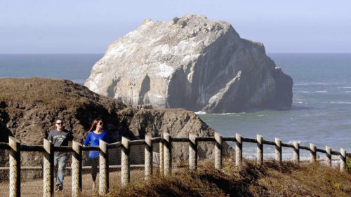
Seaside attracts families with its 1920s-era promenade and boardwalk games. Cannon Beach is its artsy cousin, filled with galleries, boutiques and views of 235-foot Haystack Rock offshore. In between lies Ecola State Park, a delight of sandy coves, forested trails and the cliff-edged cape of Tillamook Head.
The byway winds past more cliffs and coves, climbing to more than 700 feet/213 meters above the Pacific, before descending around the rich estuary of Nehalem Bay.
Garibaldi to Newport
The byway arcs inland around Tillamook Bay at Garibaldi, a hub for fishing and kayaking. In Tillamook, take a self-guided tour and sample cheeses at the Tillamook Creamery. Head west on OR-131 for a detour along the Trees to Sea Scenic Byway to the Cape Meares Lighthouse. From here, continue south along the Three Capes Scenic Loop to Cape Lookout State Park and onward to the massive sand dune of Cape Kiwanda in the little beach town of Pacific City. The route rejoins the byway north of Lincoln City, which draws kite flyers to its breezy beaches, skilled surfers to Nelscott Reef and hikers seeking solitude to the Cascade Head Preserve, with trails bending up through old-growth forest.
The fishing village of Depoe Bay bills itself as the smallest navigable harbor in the world, where fishing boats and whale-watching excursions thread through a rocky channel to the Pacific. Gray whales tend to linger here, along with the many whales that migrate along the Coast.
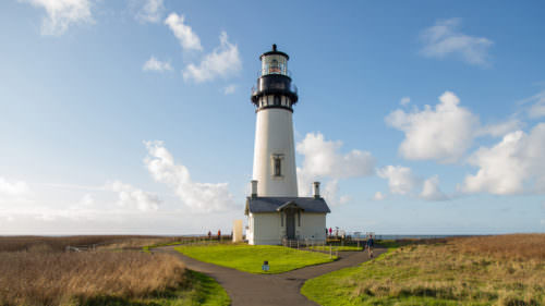
Eye tiny critters in the “marine garden” of tide pools around Otter Rock. Nearby, the collapsed sea cave called Devils Punchbowl churns with swirling seawater. Explore more marine gardens and Oregon’s tallest lighthouse at Yaquina Head Outstanding Natural Area.
Newport to Coos Bay
Newport sits on Yaquina Bay, marked by the pretty 1871 Yaquina Bay Lighthouse, Oregon’s last remaining wooden lighthouse. Visitors wander among the shops and restaurants of Nye Beach, and along the working bayfront, noisy with barking sea lions. Across the bay, the Oregon Coast Aquarium enlightens 400,000 visitors each year about what goes on below the surface with touch tanks, under water tunnels and interactive displays. With more than 40,000 students coming through its doors every year, the aquarium is a key educational resource for the state. And the nearby Hatfield Marine Science Center, part of Oregon State University, focuses much of its research on marine ecology and climate change.
Near Yachats, waves boom and swirl against the furrowed base of 800-foot Cape Perpetua Scenic Area, and trails lead through old-growth forest above. Twelve miles/19.3 kilometers south, the Heceta Head Lighthouse is Oregon’s brightest beacon and no doubt one of its most photographed. Visitors can tour the tower and stay in the lightkeeper’s home, now a B&B. At the nearby Sea Lion Caves, an elevator descends 208 feet/63 meters to an observation area in a huge natural cavern, where Steller sea lions and other wildlife gather. It’s one of the oldest private attractions along the Oregon Coast.
The byway briefly dips inland as it approaches Florence, where fishing boats and shop-filled historic buildings line up along the Siuslaw River. Across the pretty Siuslaw River Bridge, the rugged coast gives way to mile after mile of high dunes and sandy beaches, stretching all the way to Coos Bay. Near the Oregon Dunes National Recreation Area, businesses offer dune-buggy tours, sandboarding equipment and ATV rentals. The recreation area’s headquarters in Reedsport has information and interpretive displays.
Coos Bay to Brookings
The Oregon Coast’s largest city and the largest natural harbor between Seattle and San Francisco, Coos Bay is a busy port for commercial and recreational fishing, crabbing and clamming. Nearby, the Charleston to Bandon Tour Route hugs the coast, reuniting with US-101 in Bandon at the mouth of the Coquille River. Bandon is known for its world-class golf, art and sandy beaches punctuated with dramatic sea stacks.
The byway next greets the coastline at Port Orford, an exceptionally scenic fishing harbor and the start of the Wild Rivers Coast Scenic Bikeway. Harbor seals and sea lions often frequent the rocky outcrops at Port Orford Heads State Park. The Sixes and Elk rivers draining down from the Coast Range offer great salmon and steelhead fishing. The Rogue River, a Wild and Scenic River famed for its rafting and fishing, meets the Pacific at Gold Beach. Jet-boat tours power upriver for a look at the scenic Lower Rogue.
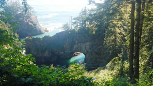
The coastal scenery dazzles on its final stretch, as the byway skims along cliffs and rocky shores dotted with tide pools. Beyond Pistol River, a famous windsurfing spot, 12 miles/19.3 kilometers of coastline are designated as the Samuel H. Boardman State Scenic Corridor, with ample overlooks, hiking trails and beach access. The byway concludes south of Brookings, a region known for its temperate “banana belt” climate and the largest stand of coastal redwoods in the state.
Want more details?
Order a free Oregon Scenic Byways guide.
For more on the Oregon Coast, visit our region page.