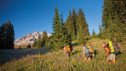
The graceful white cone of Mt. Hood beckons on Portland’s horizon, just an hour’s drive away. The 11,240-foot volcano has long been one of the city’s great escapes, but many travelers overlook the spectacular alpine hikes at Mt. Hood in favor of the Columbia River Gorge’s waterfalls, which are positioned closer to Interstate 84. Here’s a tip: Visit both areas on the loop through the city of Hood River that President Franklin D. Roosevelt took on an overnight vacation in 1937.
Roosevelt stopped to inaugurate two Depression-era projects: Bonneville Dam on the Columbia River and Timberline Lodge on Mt. Hood. Those destinations remain enduring favorites, but if you want to see more than the president did, try these Mt. Hood trails. The hikes range from easy, popular strolls to difficult, backwoods climbs.
Yes, Mt. Hood is an active volcano. Don’t worry, though: It is unlikely to blow its top like nearby Mt. St. Helens, but it does emit steam from its crater and has had five minor eruptions in the past two centuries. Since its last major eruption in 1781, contorted whitebark pine and scenic alpine wildflower meadows have managed to grow on the volcanic-ash slopes at timberline.
The most popular destination in the mountain’s beautiful high country is Timberline Lodge, where the Pacific Crest Trail and the round-the-mountain Timberline Trail connect. Be aware that deep snow buries trails at this elevation from about late October to early July. Trails lower on the volcano’s flanks — to waterfalls, reflecting lakes and mossy rainforests — are generally open from April to December.
Nearby Mt. Hood Meadows is also home to a number of hikes, which are now easy to get to from the base area thanks to 8 miles of newly constructed trails. These trails pass through wildflower meadows to reach trails with stunning overlooks and waterfalls, including Umbrella Falls and Sahalie Falls.
Know before you go: The Mt. Hood National Forest has eight nationally designated wilderness areas, a total of 311,448 acres, which means the lands are protected by the federal government to be preserved in their natural condition. In most cases, you’ll want to make sure you have purchased a Northwest Forest Service Pass (either online, by mail or at an official retailer) before arriving at the trailhead. Additionally, hikers are often required to carry a wilderness permit (free registration at trails) and should follow Leave No Trace principles to ensure that our wilderness will stay wild.
Old Salmon River Trail
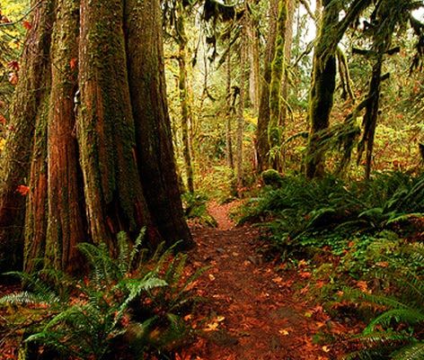
Near the base of Mt. Hood, you’ll pass one of the area’s most accessible old-growth forests, where moss drapes the limbs of giant trees along the green-pooled Salmon River. Turn off Highway 26 at the town of Zigzag for an easy 2.1-mile stroll on the riverside trail. You’ll pass 10-foot-thick red cedars and small sandy beaches with deep pools suitable for a chilly summer swim. The trail is typically open year-round. (photo by Greg Lief)
Getting there: Drive Highway 26 east of Portland 42 miles to the town of Zigzag, and turn right on Salmon River Road 2.7 miles to a trailhead pullout on the right. Expect to pay $5 if you don’t already have a Northwest Forest parking pass. If you want to hike the Old Salmon River Trail one way, drive a shuttle car another 2 miles up Salmon River Road and leave it at the Green Canyon Campground.
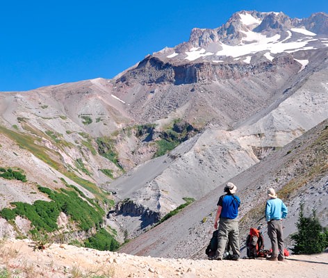
Zigzag Canyon
Surprisingly few visitors to Timberline Lodge venture into the scenic alpine landscape that lured hotel builders here in the first place. For a sample, take the Pacific Crest Trail west through gorgeous wildflower meadows with views to Mt. Jefferson and the Three Sisters. After 2.2 miles, you’ll reach a jaw-dropping viewpoint of Zigzag Canyon, a 700-foot-deep chasm gouged into Mt. Hood’s cindery flank by the glacier-fed Zigzag River. Turn back at the viewpoint of Zigzag Canyon, as the trail ahead becomes more difficult. This hike is typically best in summer and early fall. (photo by Cheryl Hill)
Getting there: From Portland, drive Highway 26 toward Mt. Hood 54 miles. On the far side of Government Camp, turn left for 6 miles up to the lodge’s huge parking lot. To reach the trail, start by walking past the right-hand side of Timberline Lodge on a wide, paved walkway uphill. After 200 yards, turn left on the Pacific Crest Trail for the easy 2.2-mile hike.
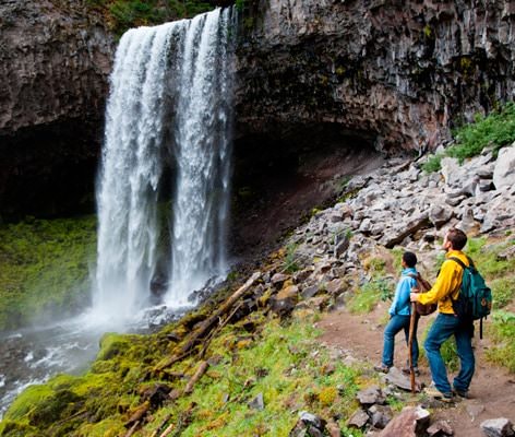
Tamanawas Falls Trail
The Northwest Indians believed everyone has a tamanawas—a friendly guardian spirit. Tamanawas Falls seems as though it might be Mt. Hood’s guardian, an inspiring 100-foot curtain of white water in a green canyon at the mountain’s eastern base. The easy 1.9-mile path to the falls is a delight, with scenic footbridges and lots of access to mossy-banked Cold Spring Creek. The open season for this trail is May to October. (photo by Tyler Roemer)
Getting there: Drive Highway 35 around Mt. Hood to the Tamanawas Falls Trailhead near milepost 72, about 0.2 miles north of Sherwood Campground. Expect to pay $5 if you don’t already have a Northwest Forest parking pass.
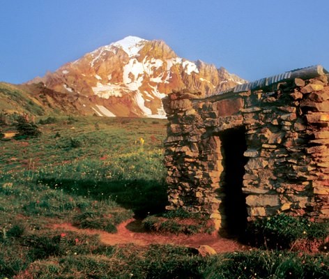
McNeil Point Trail
Wildflowers, tumbling brooks and craggy mountain vistas are highlights of a difficult but spectacular trail that climbs for more than 4 miles to the historic McNeil Point shelter high on Mt. Hood’s shoulder. In an alpine meadow above the tree line, the Civilian Conservation Corps built a 10-by-10-foot stone hut in the 1930s. The hike from the Top Spur Trailhead follows portions of the Pacific Crest and Timberline trails on the way up. After reaching the Top Spur Trailhead, you’ll hike up the trail half a mile, turn right on the Pacific Crest Trail for 60 yards, turn left on the Timberline Trail for 3 miles, and turn right on a 1.1-mile path up to McNeil Point. This hike is typically best in spring and early fall. (photo by William L. Sullivan)
Getting there: Drive Highway 26 east of Portland 42 miles. Across from the Zigzag Inn, turn left onto East Lolo Pass Road for 4.2 miles. Then fork right onto Road 1825 for 0.7 miles, go straight on Road 1828 for 5.6 miles, and fork to the right on gravel Road 118 for 1.5 miles to the Top Spur Trailhead. With this hike and others on the list, expect to pay $5 if you don’t already have a Northwest Forest parking pass.
Trillium Lake Loop Trail
The closest large lake to Mt. Hood has a stunning reflection of the mountain that is often used on Oregon postcards. See it as you circle the lake on a 2-mile loop path that’s easy enough even for wheelchairs. Start at a campground with a popular picnic area and fishing dock. Motorboats are banned, so the lake is also a quiet place for canoeing. This trail typically opens for hikers in May and is best in summer and early fall. (photo by Nickie Bournias)
Note: A portion of the trail’s boardwalk is closed, so visitors can walk to either end of the closed section but not all the way around the lake.
Getting there: Drive Highway 26 east past Government Camp 3 miles, and turn south at a Trillium Lake sign for 1.6 miles. Expect to pay $5 if you don’t already have a Northwest Forest parking pass.
Cooper Spur
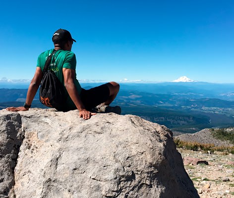
The highest hiking trail on Mt. Hood switchbacks up Cooper Spur’s cindery shoulder 3.9 miles to Tie-In Rock, where mountain climbers traditionally rope up. From this vertiginous perch, peaks from Mt. Rainier to the Three Sisters dot the horizon. The massive Eliot Glacier writhes below, a splintered river of ice. And if the thought of a 2,800-foot ascent leaves you winded, Cooper Spur has a more moderate option: a 1.3-mile hike to a historic stone shelter that still has a good glacier view. For the hike, walk across the primitive campground 200 feet to a message board, and go steeply uphill to the left on Timberline Trail #600. After 0.2 miles, turn left at a junction, following the Timberline Trail another mile to an X-shaped junction. Turn, taking the Cooper Spur Trail up 200 yards to the stone shelter. For a longer hike, continue up past the shelter 2.6 switchbacking miles to trail’s end at Tie-In Rock. Beyond this, climbing equipment is required. This hike is best in summer and early fall. (photo by Olivia Allison)
Getting there: Drive Highway 35 around Mt. Hood to the Cooper Spur Ski Area turnoff between mileposts 73 and 74. Head west on Cooper Spur Road for 2.3 miles to Cooper Spur Junction, turn left onto Cloud Cap Road for 1.4 paved miles, ignore the ski area entrance on the left and continue on a slow, bumpy, one-lane gravel road for 8.1 miles. At a T-shaped junction, turn right toward Cloud Cap 0.5 mile to a restroom marking the trailhead on the right. Expect to pay $5 if you don’t already have a Northwest Forest parking pass.