Scissor-sharp peaks and ridges define the Elkhorn Mountains of northeast Oregon, where gold-mining boomtowns have given way to a mother lode of natural beauty on this 106-mile/171-kilometer tour.
This byway packs plenty of sights into a 106-mile/171-kilometer loop through the mountains west of Baker City, long the lucrative hunting grounds of the Plateau Indian tribes and, later, where miners came to seek their fortunes. The true treasures are the Elkhorn Mountains and Baker Valley themselves, rich in beauty and history.
Baker City
Already established as an agricultural center, Baker City flourished with the discovery of gold in Oregon in the 19th century. The “Queen City of the Mines” grew wealthy providing transportation, food and supplies to thousands of miners in the nearby mountains. When other towns dried up after the gold rush, Baker City successfully transformed into a hub for logging, ranching and the transcontinental railroad.
Downtown storefronts and homes still show off Baker City’s opulence, especially the 1889 Geiser Grand Hotel, a meticulously restored Italianate beauty with mahogany columns and a stained glass ceiling. The Baker Heritage Museum, housed in a 1920 natatorium, has exhibits on ranching and mining, and an excellent mineral collection.
Along the Powder River
The byway follows OR-7 through ranchlands, turning west along the Powder River. It threads through the basalt Blue Canyon and enters the Wallowa-Whitman National Forest, where grasslands and juniper hills give way to ponderosa pine forest.
The Powder River’s Mason Dam forms 2,235-acre Phillips Lake, a popular spot for boating, fishing and waterfront camping. The lakeside Mowich Loop Picnic Area provides access to the North Shore Trail, part of the Phillips Lake Trail System, which winds along the lake for more than 6 miles/9.6 kilometers and is open to hiking, mountain biking and horseback riding.
Gold Country
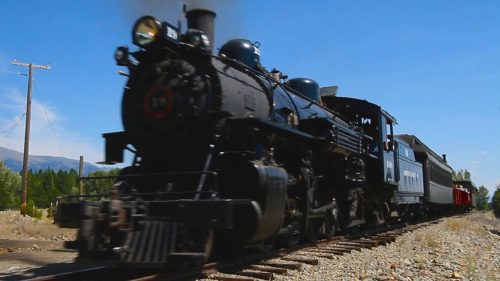
Past Phillips Lake, the Tailings Overlook gives evidence of the intensive gold mining that occurred in this area in the mid-19th century. A few miles west in McEwen, the Sumpter Valley Railroad Stump Dodger follows the narrow-gauge track used by miners and loggers over a century ago. The round-trip train ride to Sumpter takes about two hours.
Sumpter’s mining heyday came around 1900, when thousands of miners chiseled and dredged millions in gold from the Elkhorn Mountains and Powder River. It had 16 saloons, three newspapers and an opera house, until a fire destroyed its business district in 1917. The massive, floating Sumpter Valley Dredge is the centerpiece of a State Heritage Area.
As the byway climbs toward Blue Springs Summit, you’ll get great views of the Elkhorn Mountains and their unusual layered geology: sedimentary rock topped with granite and capped with flows of volcanic basalt. The 5,864-foot/ 1787-meter summit is a popular snowmobile staging area in winter, offering access to more than 150 miles/ 241 kilometers of trails.
Granite and North
Like Sumpter, the town of Granite saw plenty of gold-rush activity. Many of its now-abandoned buildings still exist, along with stories of local characters like ’49 Jimmie, whose only companion was a rooster with whom he shared all his meals.
The route heads north along FR-73. The Ah Hee Diggings Interpretive Site explains the rock mounds paralleling Granite Creek, made by Chinese laborers piling up boulders by hand as they worked the streambed for gold.
At the North Fork John Day Campground, the byway meets the eastern end of the Blue Mountain Scenic Byway. The Elkhorn Drive Scenic Byway turns right here, paralleling the North Fork John Day River, then climbs to the Elkhorn Mountains’ summit. At 7,392 feet/2,253 meters, it’s the highest point on the route.
The Lakes District
The byway continues northeast into a beautiful area of mountain lakes, including Grande Ronde and Anthony, popular for camping, hiking and other recreation. Just before the Anthony Lakes Campground, the 23-mile/37-kilometer Elkhorn Crest National Recreation Trail departs south, skimming along the ridgeline above clear streams, mountain meadows and lakes. Anthony Lakes is also home to an alpine ski area known for its deep, dry powder — accessible by ski lift from the small, family-friendly ski area or via snow cat for back-country shredding and epic mountain biking in the summertime.
From Anthony Lakes, the byway descends steeply through a narrow canyon before emerging in the broad Baker Valley. Head south to Haines, where the Eastern Oregon Museum exhibits bootleggers’ stills and other artifacts from the region’s pioneer past. US-30 leads back to Baker City.
Want more details?
Order a free Oregon Scenic Byways guide.