Witness the forces of nature along this 68-mile/109-kilometer drive, from trails through grand forests to a ragged headland that displays the foamy power of the Pacific.
You can’t miss Oregon’s rugged beauty as you travel along rushing rivers and wild coastlines on this newly designated byway. The route also introduces you to the region’s equally dramatic history — leading the way to some unsung treasures.
Tualatin Valley
Thirty miles/48.2 kilometers west of Portland, the Oregon Coast Range begins to rise up at Banks, an agriculture community dotted with farms, vineyards and U-pick orchards. It’s the southernmost trailhead for the 21-mile/33.8-kilometer Banks-Vernonia State Trail, a paved car-free path through rural landscapes and woodlands. Highlights include a high wooden trestle at Buxton and L.L. Stub Stewart State Park. From Banks, the byway follows OR-6 West, past tasting rooms that showcase the renowned wines of Tualatin Valley.
Tillamook State Forest
You enter the Tillamook State Forest near the Gales Creek Overlook, around mile marker 34. One of the West’s largest known series of wildfires — collectively dubbed the Tillamook Burn — began near this site in 1933. This and subsequent burns in 1939, 1946 and 1952 eventually encompassed some 355,000 acres. A kiosk briefly explains the incredible restoration effort.
The byway twists along the Devils Lake Fork of the Wilson River, with plenty of pullouts to stop and enjoy the views. At staging areas like Browns Camp, dirt bikes and other off-highway vehicles (OHVs) access around 250 miles/ 400 kilometers of OHV trails in the surrounding forest.
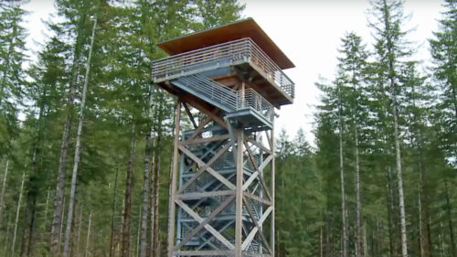
A 40-foot-high replica fire lookout marks the entrance to the Oregon Department of Forestry’s hands-on Tillamook Forest Center. Interactive exhibits tell the stories of the area’s native tribes, early settlers, and how Oregonians helped turn the Tillamook Burn into a thriving forest. Aided by citizens of all ages hand planting 72 million seedlings, the Oregon Department of Forestry pioneered many of the tools and replanting techniques still used today. Behind the center, a suspension bridge spans the Wilson River, where you can spy salmon and access the 24-mile/38.6-kilometer Wilson River hiking and mountain-biking trail.
Tillamook
As the byway descends from the Coast Range, the landscape broadens into grassy pastures where dairy cows graze. A million hungry visitors a year get a taste of Tillamook’s dairy industry at the Tillamook Creamery, with self-guided tours, exhibits, yummy menu and lots of cheese samples. Nearby, Blue Heron French Cheese Company has friendly farm animals plus wine-and-cheese pairings. Dairy products once traveled from Tillamook Bay to Portland by railroad. Now the public can ride those rails from Bay City to Tillamook with Oregon Coast Rail Riders, where you cycle on tracks through meadows and over estuaries on custom-made, pedal-powered carts.
Three miles/4.8 kilometers south of Tillamook, the Tillamook Air Museum displays an array of aircraft, from early gyrocopters to decorated fighter jets. The most remarkable artifact might be the building itself: Built in 1942 to house World War II surveillance blimps, the immense wooden structure arches 15 stories high and more than 1,000 feet/304.8 meters long. This little-known national treasure is one of the few remaining structures of its kind.
Netarts Highway to Cape Meares
From Tillamook, the byway crosses Highway 101, continuing west on OR-131 to meet the Pacific at Netarts, where a long spit (part of Cape Lookout State Park) forms the protected waters of sandy Netarts Bay, famous for its succulent oysters and harvested salt. The byway hugs the Coast as it continues north to Oceanside, known for its fine beaches, good surf waves and lovely views of Three Arch Rocks just offshore.
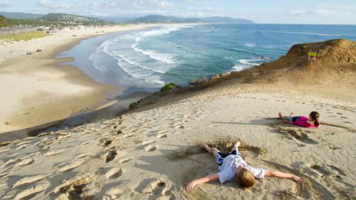
The byway reaches its dramatic end at Cape Meares State Park, a rocky promontory 200 feet / 61 meters above the crashing ocean waves. The 1889 Cape Meares Lighthouse marks the point, notable for its large first-order Fresnel lens, visible to mariners for 21 miles/ 33.8 kilometers. The park’s overlooks offer vantage points for spotting migrating gray whales and thousands of seabirds — including whimsical tufted puffins that frequent the rocky cliffs and islands.
You’ll also find ample salty scenery heading south: The Three Capes Scenic Drive links Cape Meares with Cape Lookout and Cape Kiwanda, and joins the grand Pacific Coast Scenic Byway at Pacific City.
Want more details?
Order a free Oregon Scenic Byways guide online.