Driving through the landscapes of Southern Oregon’s Lake County is like entering a painting where the oil hasn’t quite dried. The skies are huge, cut with dramatic scarps and overlaid with a palette of tawny browns and pale greens. Lakeview is about three hours due east from where I live, near Ashland. I’m lucky to have a friend, Nick, who lives in Lakeview and is willing to let me in on some of Lake County’s lesser-known attractions. Though short on people (pop. 7,800), the region has plenty to offer if you like dramatic geology, native history and odd points of interest far from any pavement.
Whichever adventure you choose, you will likely come away with a series of hauntingly beautiful memories: the chain of lakes in the Warner Valley at dusk, the mysterious images etched into ancient rock, the scent of sagebrush. Here’s how to explore.
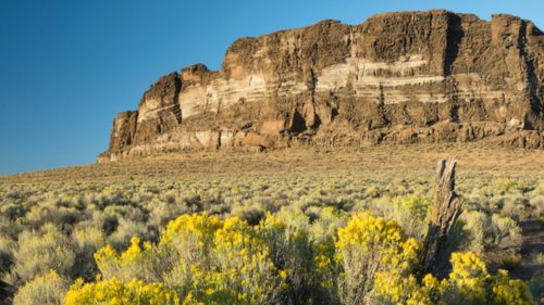
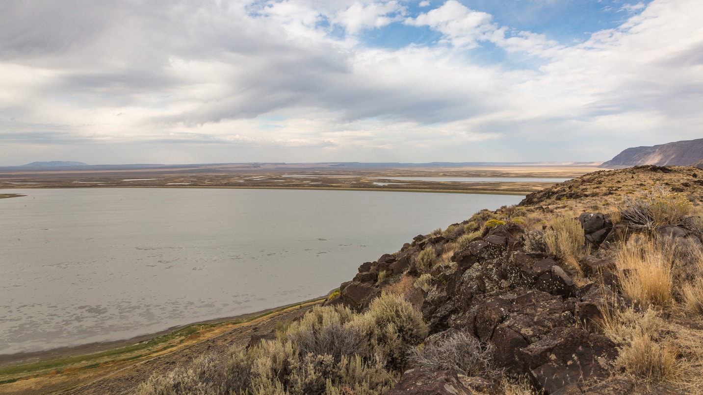
Abert Rim and Lake Abert
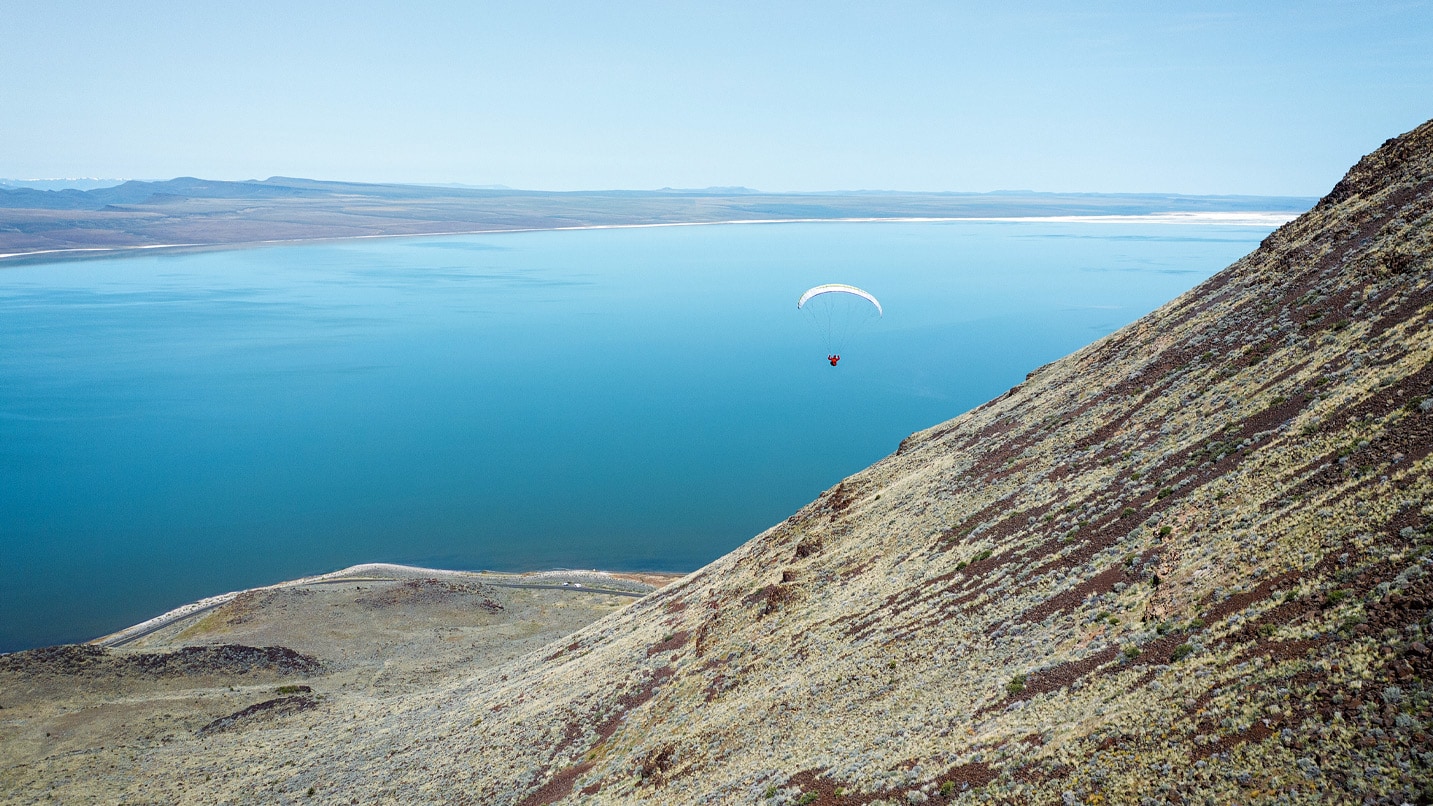
The town of Lakeview makes a great home base for a series of mini adventures north and east. In town, you can grab a hearty breakfast or takeout lunch at Tall Town Cafe drive-thru. For an easy day trip, drive 30 miles north on U.S. Route 395 to experience Lake Abert and the Abert Rim, a basalt escarpment that towers 2,500 feet above the salty lake. (In fact, it’s Oregon’s only saltwater lake.)
There are plenty of pullouts to stop and ponder the landscape. I’ve always had a hard time wrapping my head around the pace and structure of geologic events, but the landscape here is more transparent, the signature of physical forces more obvious. You can see the ghosts of ancient shorelines written on the rocks; the bones of the land lie exposed.
According to geologists, Abert Rim is earth crust tilted sideways — a horst, or raised fault block — created as the crust thinned and pulled apart. The lake is in a graben, a sunken chunk of crust. John C. Fremont, a military explorer who traveled through the region in the 1840s, named the lake after James Abert, commander of the Corps of Topographical Engineers. The rim was later named for the lake.
It may be hard to believe today, but this region — home to the Northern Paiutes — was once densely populated by wildlife, birds and humans. Lake Abert is a remnant of the much larger Lake Chewaucan, which was 375 feet at its deepest point. Even as the lakes contracted and grew saltier, they still supported plenty of life. (If you time your visit for fall, you may catch the flocks of migratory shorebirds that use the lake as a pit stop, gorging on brine shrimp and alkali flies before resuming flights north and south.)
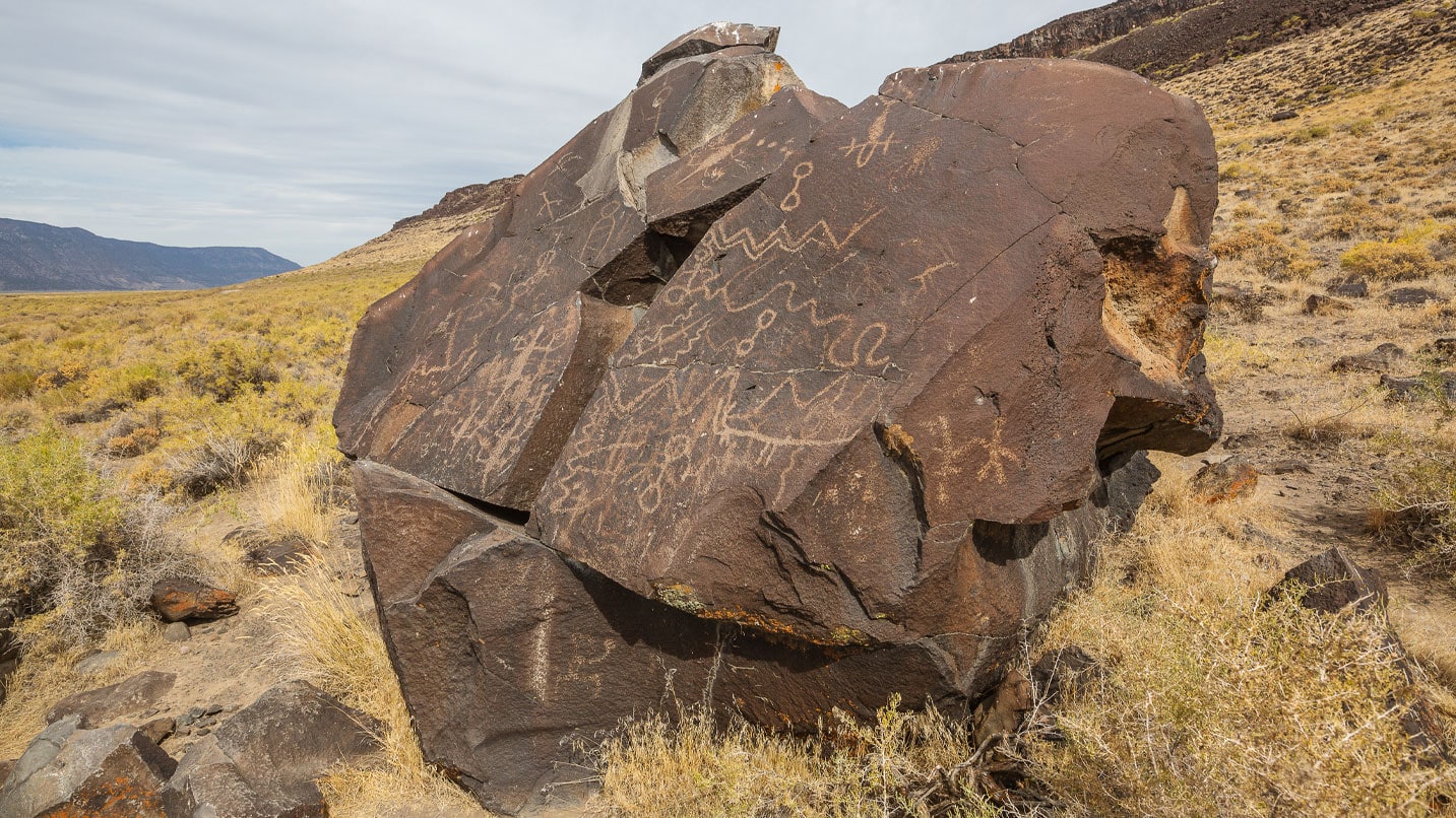
Some of the oldest archaeological sites in North America are here. Along Lake Abert’s shores are hundreds of sites representing 11,000 years of occupation by the Klamath, Modoc and Yahooskin Tribes: villages with clusters of pit houses, and petroglyph galleries. While a bit hard to find, you can look for petroglyphs on the boulders along the lake shore near the Abert Rim geological marker sign.
Just north of Lake Abert is a site where two items of major geologic significance have been found. Archaeologists believe the site served as a temporary camp where people refurbished ancient weapons — known as Clovis and later Western Stemmed projectile points — with fresh ones, fashioned from the area’s plentiful obsidian. At Fort Rock Cave, just two hours north of Lakeview, more than 70 pairs of ancient bark-and-sagebrush sandals were found buried under a thick layer of Mt. Mazama ash.
A word about rocks and artifacts: While rockhounding is a popular activity in Lake County, disturbing or collecting artifacts is strictly forbidden. If you find a bit of obsidian that looks like it could have been worked by human hands, best to leave it in place.
After driving the length of Lake Abert, continue north another 30 miles to Alkali Lake or turn around for another view of the dramatic swoop of land and swath of lake on the return trip, and contemplate the fact that this dramatic land is composed of lava that flowed over 15 million years ago.
Things change. Sometimes dramatically.
Wetlands, a Glass House and Sunstones
Another satisfying day trip starts by heading east on Oregon Route 140. Plush Cutoff Road and Hart Mountain Road will take you across the Warner Wetlands — be on the lookout for bald eagles. Turn right at the intersection and drive along Hart Lake’s eastern shore. If you stop and look carefully, you can spot petroglyphs on the car-size boulders scattered about the base of the escarpment. They are mostly on the flatter, lake-facing boulders: images of hoofed mammals; hunters with bows; figures that seemed half-insect or reptile and half-human; enigmatic squiggles and lines.
The images were made by carefully chiseling out material, exposing “fresh” rock underneath. Some are thousands of years old. The Hart Lake examples are just a few of the hundreds of petroglyphs in the area and hint at a rich and continuous Indigenous presence in the region. Please be respectful and don’t touch the images or climb on the rocks; do take as many photos as you like.
If you’re feeling adventurous, you can continue on and try to find the Glass House. Once a private residence, now publicly owned, the Glass House is weird and wonderful and totally worth the effort, assuming you have a four-wheel-drive vehicle. It can be reached from the road that curves up from the east side of Hart Lake. Take the first Jeep track to the right and start looking to the northwest for the roof, which is easy to pick out among the sagebrush.
The house has many quirky touches: a four-poster bed with colorful rings adorning each post; orange kitchen cabinets; metalwork on the roof. A vast but dilapidated wooden deck extends in a wedge to the east. The owner supposedly traveled there via helicopter.
Not much is known about the person who dreamed up the Glass House. I kind of like that. Like the landscape, it leaves much to the imagination.
After your Hart Lake adventures, consider ending your day by hunting for sunstones — Oregon’s official gemstone — at the state’s Oregon Sunstone Public Collection Area, 23 miles from Plush. Sunstones are feldspar crystals captured in ancient lava, and they come in a variety of captivating orangey and pinkish hues.
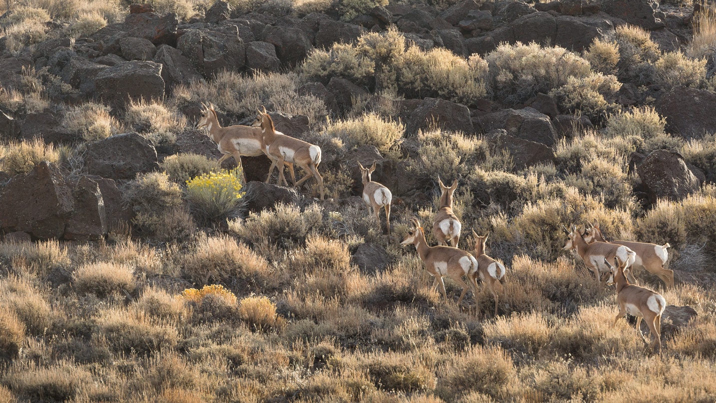
Petroglyphs, Pronghorn and Hot Springs
If glimpsing the petroglyphs at Hart Lake whets your appetite, you can turn around and head to Petroglyph Lake, located within the Hart Mountain National Antelope Refuge, which was designated to protect the herds of pronghorn that graze there.
Hart Mountain Road climbs above a chain of lakes and into the refuge; the trailhead to Petroglyph Lake is a mile east of the refuge visitor center. Petroglyph Lake is an easy but exposed 1.6-mile-hike on a mostly level trail. The small lake often fades to a wet meadow, but along the western edge is a gallery of 60 petroglyphs that include human and insect-like figures, spirals and horned creatures.
After a long day of exploring, plan to end your outing as I did, with a soak in Hart Mountain Hot Spring, at a campground of the same name. There are two options: a developed pool near the parking lot and an undeveloped spring about a quarter of a mile on foot.
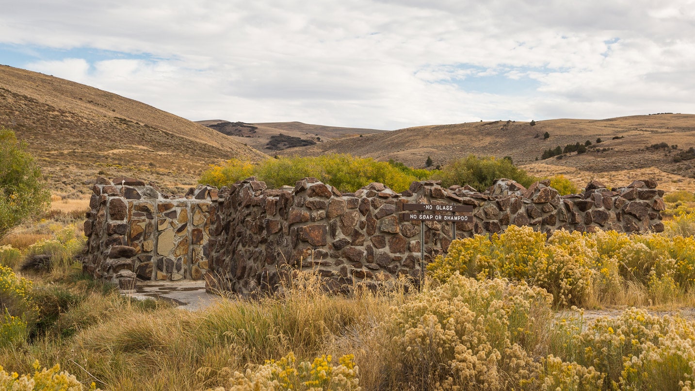
The developed spring is surrounded by a low stone wall and includes a couple of benches, which are convenient for placing towels and clothes. The undeveloped spring doesn’t offer the same conveniences, and you must hike in about a quarter of a mile; hence, it is less likely to be occupied — a bonus when trying to maintain physical distancing. The bottom of the pool is soft squishy mud, so if you’re squeamish (or modest), bring a swimsuit.
That you can submerge your body in 100-degree water while there’s snow on the ground is thanks to groundwater heated by the earth’s mantle. This same geothermal energy is harnessed in the town of Lakeview, where it heats hospitals and local schools.
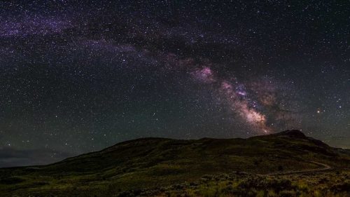
If you spend the night at the campground, you can marvel at the expanse of stars and enjoy the breathtaking landscape in the magical early-morning light. But at 6,000 feet it can be chilly, even in summer. Alternatively, consider lodging in Lakeview at Hunter’s Hot Springs Hotel. A resort first established in the 1920s, it’s under new ownership and was recently remodeled. In addition to the concrete mineral soaking pool, Hunter’s Hot Springs boasts its own geyser, Old Perpetual, which spews scalding water 90 feet into the air every couple of minutes. Some rooms are dog-friendly — a plus for me and my dog, Roca.
If You Go:
Best time to go — While the landscape is lovely in winter, the weather is more predictable in late spring through fall. The Hart Mountain refuge is open all year long; however, unpaved roads may be snowy, muddy, and impassable in winter and early spring. Always check conditions before you go. Temperatures in this desert climate swing 40 degrees from day to night in summer, and although summer high temperatures rarely rise much above 85, there is little cover. Bring sun protection and layers.
Know your way — Check in with the BLM Lakeview District or Hart Mountain National Antelope Refuge for the latest travel advisories and to confirm what’s open.
Be prepared — Once outside of Lakeview proper, services are few and far between, so gas up, have plenty of food and water, carry extra layers and blankets in your vehicle, and tell someone where you’re going. Find more tips on how to Take Care Out There. Download a map of your route so you can access it offline, as cell service is limited. Check out the Oregon Outback Adventure Map for more details and inspiration.