


Make sure you have your big girl/big boy shorts on for this one. This loop may be only a little over 12 miles, but it packs in more than 3,000 feet of climbing (do the math; if it’s a loop the gain is all in about half of that). That said, here’s a chance to delve even farther into the wild, where few riders go, and the reward is a quiet pedal through a spectral stretch of forest – oh, and of course some indelible views.
This route takes some effort to get to, but that’s part of the point, isn’t it. You’ll actually be starting at the headwaters of the Middle Fork of the Willamette River headwaters, in the crest of the Cascades. From Oakridge, head east on Hwy 58 for a couple miles and turn right on Hills Creek Rd (NF21). After half a mile, turn right again to stay on NF21 and travel for 31.6 miles, where you’ll follow the signs left on NF2154 to Timpanogas Lake. After another 9 miles (7 of it on rough gravel), you’ll see Timpanogas Campground on your left. There’s a day-use parking area to the right after you come to the lake. (Note: Some mapping tools might suggest you take NF6010 past Crescent Lake if you’re coming from Bend—we do not recommend this route.) There are vault toilets; a Northwest Forest Pass is required.
Once you’ve completed the journey to get here, take a few moments to orient yourself and tune in to your surroundings. The Sawtooth and Cowhorn mountains loom above you, poking through the trees; their slopes are part of the reason Central and Eastern Oregon are so wonderfully dry: these ranges grab every last bit of moisture as weather fronts pass over into Central Oregon. As a result, hundreds of tiny vernal ponds speckle the forest, feeding a few larger lakes like Indigo, June and Summit, before cascading into the upper reaches of the Willamette and Deschutes rivers.
The forest here is ethereal. The prevalent canopy is scraggly mountain hemlock, draped with moss like a haunted-house prop. The understory beneath is open and stark, with the graduated, monotone trunks blending into the shadows.
The route begins by skirting around the lake’s north shore, past the Timpanogas Cabin and up through the timber stands toward Cowhorn Mountain. The terrain is not technically difficult, but it’s unrelentingly steep starting about 0.3 miles in – from that point it’s a 2,100-foot climb over 3.3 miles. You’ll top out at 7,400 feet.
At about 3.8 miles, before you crest, you’ll have the opportunity to go multi-modal on this adventure. Consider packing a pair of hike-worthy shoes; you can stash your bike in the bushes and trek up the Cowhorn Connector to the Pacific Crest Trail, from where there’s a short but steep summit trail to the shoulder of Cowhorn Mountain. (Reminder: Bikes aren’t allowed on the PCT.) Climbing through forest means you don’t get a lot of broad, expansive views, so if you really want to see the lay of the land, this side trip will take you above the treeline right on the spine of Oregon – where splendor unfolds in every direction. Mount Thielsen and Crater Lake to the south; Crescent Lake, Mt Bachelor and the Three Sisters to the northeast; Diamond Peak looming close by to the northwest. Spend a few moments taking it all in, and then head back into the shelter of the forest.
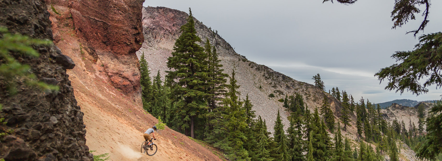
From here the adventure really gets going. A short, swooping descent entices you, but then you’ll face the reckoning of an even steeper climb, which pushes you over the distinct spine of the mountains and into a third watershed: the North Umpqua River. Pedal, working hard, through surreal groves of thousands of “pistol butt” trees, formed by the heavy snow pack sliding and bending the trees in their early years. The trail steepens (more?) and pushes you out into the loose scree of the Sawtooth’s ochre slopes, where you’ll navigate tight switchbacks past this trail’s iconic hoodoo formations.
When you finally attain the high point, dive into a fast descent west along a ridgeline, punctuated by surprisingly steep and technical plunges up and down the topographic bands radiating out from the peaks. The final two miles offer pure fun, dropping you down that last slope, arriving out of breath but exhilarated, back on the shore of Timpanogas Lake.
Notes: If you’re still up for more riding while you’re all the way up here already, both Indigo and June lakes have trails that offer a few more miles and some stunning alpine backcountry campsites.
Notes: If you’re still up for more riding while you’re all the way up here already, both Indigo and June lakes have trails that offer a few more miles and some stunning alpine backcountry campsites.