High-mountain lava fields, snowy volcanic peaks and panoramic Cascade-pass views present a striking world of contrasts on this 82-mile/132-kilometer loop route northwest of Bend.
Oregon’s highest mountains create wildly contrasting landscapes, which you’ll clearly witness on this drive. On the east side of the Cascade Mountains, golden grasslands and lodgepole pine prevail; over the passes, you’ll cross into fir and cedar forests and mossy-green river valleys. Fire juxtaposes with ice, too, where snowy, glaciated peaks rise up from stark black lava fields. It’s a region of national significance — home to several endangered species, centuries-old pristine forest and noteworthy volcanic geology — that you can experience up close on a weekend road trip.
Sisters and Santiam Pass
Start the loop in Sisters, named for the Three Sisters — 10,000-foot/3,048-meter volcanic peaks rising up to the southwest. Sisters has a charming Western ambience, with boxy 1800s-style architecture along its main street and storefronts filled with galleries, Western wear and antiques.
To travel the loop counterclockwise, follow the byway northwest on US-20/ OR-126. Near the 6,436-foot/1,961-meter cinder cone of Black Butte, a side road leads north to Camp Sherman. A cool spot along the spring-fed Metolius River, it’s been a favorite summer retreat since the homesteader days, when wheat farmers came to fish and escape the high-desert heat. A scenic viewpoint overlooks the Metolius headwaters, meadows and a grand view of Mt. Jefferson to the north.
Continuing on the byway, you’ll get a prominent look at Mt. Washington as the road climbs toward Santiam Pass. On the way, the road skirts the pretty sliver of Suttle Lake, carved by glaciers and popular for boating and fishing.
Santiam Pass takes its name from the Santiam Indians, a Kalapooian tribe native to the area. Several ashen buttes and other volcanic features are visible from the 4,817-foot/1,468-meter pass. The Pacific Crest National Scenic Trail crosses here too, a particularly memorable stretch of the famous Canada-to-Mexico route, threading high among several volcanic peaks. This section of the road passes by mysterious Lost Lake, which fills up with water every spring and disappears in the fall down a hole into a lava tube. The byway descends the pass, then turns south on OR-126.
OR-126: The McKenzie River Highway
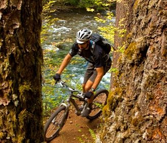
This stretch of the route showcases the beautiful peacock-blue waters of the Upper McKenzie, as the river tumbles south over waterfalls and through lava flows and here parallels the West Cascades Scenic Byway. The McKenzie River National Recreation Trail also follows the river’s route for more than 26 miles/41.8 kilometers, with several well-marked access points from the byway. Popular with hikers and mountain bikers alike, the trail was named by Outside magazine as one of its 10 Great American Mountain Biking Trails.
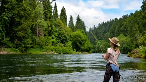
Fly-fishers, too, hold the McKenzie in high regard, casting dry flies for redband and rainbow trout. The McKenzie drift boat originated here — a dory with flared sides, a pointed stern, and a flat bottom with continuous rocker — specifically designed for maneuverability in rapids. Many area guides work the McKenzie and run its rapids in one of these time-tested boats.
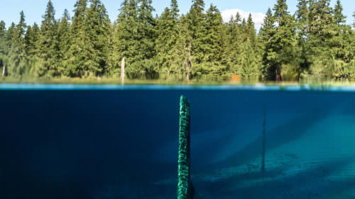
Clear Lake is the headwaters of the McKenzie River, fed by numerous springs and formed when an ancient lava flow dammed the stream. A 5-mile/ 8-kilometer trail encircles the lake, but you can get a good view just by crossing a small footbridge or paddling in a canoe. The lake’s clarity is remarkable. A submerged 3,000-year-old forest — preserved by the cold waters — remains easily visible more than 100 feet/ 30 meters below the surface.
Lava flows also created Sahalie Falls and Koosah Falls downstream, two beautiful cascades that you can see by hiking an easy 2.6-mile/4.1-kilometer loop trail. For non-hikers, Sahalie Falls can be viewed from the parking lot. The greatest volcanic oddity is farther downstream at the Tamolitch Pool, also listed on maps as “the Blue Pool.” Here the river reappears from a 3-mile/ 4.8-kilometer underground detour through a lava tube into a pool that is an impossibly iridescent blue.
OR-242: McKenzie Highway
Past Belknap Springs, the byway swings east onto OR-242, the McKenzie Highway. Snow closes this seasonal road each winter, through mid-June. See the Oregon Department of Transportation’s messaging about this closure. Note that the road is not maintained while it is closed, and those who access the road when it’s closed do so at their own risk.
In 9 miles/14.4 kilometers, a 1.3-mile/ 2-kilometer trail leads through lava fields reclaimed by forest to Proxy Falls. The lovely two-part falls spills over mosses and ferns, its waters largely disappearing right back into the green-blanketed rocks. The byway then switchbacks steeply through an area known as Deadhorse Grade, climbing nearly 1,200 feet/365 meters in just 4 miles/6.4 kilometers. You’ll be treated to more outstanding volcano views, this time of North Sister and Middle Sister. Double the view with a short side trip up to Scott Lake, which mirrors these ragged peaks.
The forest abruptly ends just shy of McKenzie Pass, replaced by an expanse of dark and broken lava that stretches for 65 square miles/104.6 square kilometers. It’s one of the most recent and most remarkable examples of volcanic activity in North America, the result of eruptions from Belknap Crater about 2,000 years ago. Learn more on the Lava River National Recreation Trail, a paved path through lava gutters and ridges. The Dee Wright Observatory — constructed of lava rock by the Civilian Conservation Corps in 1935 — has viewing ports to see many surrounding Cascade peaks. Mt. Washington, just 5 miles/8 kilometers away, looks close enough to touch.
From here the route begins its descent, with one last overlook at Windy Point before reentering the forest and returning to Sisters.
Want more details?
Order a free Oregon Scenic Byways guide.