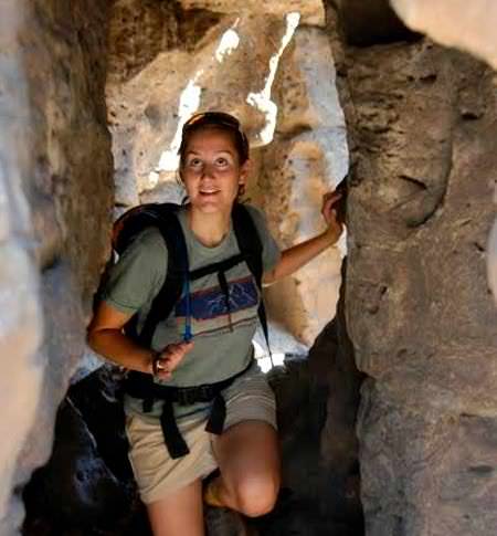
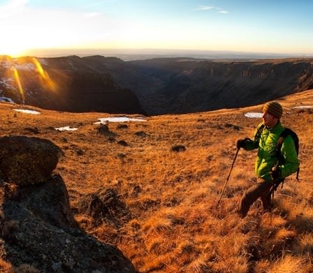
One June morning four years ago, Sage Clegg saddled her bike with about 12 pounds of backpacking equipment and rode toward a region of Oregon’s high desert known as the Badlands Wilderness, 15 miles east of her home in Bend. Along the way, she got lost, accidentally taking a dead-end road. She had to hop a barbed-wire fence and push her bike through dense swaths of sand to reach the desert trailhead that marked the official start of her journey. When she finally arrived, she stowed her bike for a friend to retrieve, hoisted her backpack onto her shoulders and continued on foot.
Clegg, a wildlife biologist and avid thru-hiker, spent the next month trekking through Southeastern Oregon, traversing both Hart Mountain and Steens Mountain, crossing canyons and scrubland, and amphibiously tracing the length of the West Little Owyhee River. In all, she walked 600 miles and, having arranged for friends to drop her bike at certain points along the trail, pedaled another 200. She endured swift 40-degree changes in temperature, sudden downpours, snowstorms and long stretches of parched terrain, relying on seven water caches that she had spaced along her path. About 37 days later, near the border of Idaho in Lake Owyhee State Park, Clegg became the first person to complete the Oregon Desert Trail (ODT) in its entirety.
Compared to famous routes such as the Appalachian Trail, the ODT is young and obscure. It began to take shape one evening in 2010 in the restless mind of Brent Fenty, executive director of the Oregon Natural Desert Association, a nonprofit organization dedicated to protecting the state’s high desert.
While sitting in bed beside his wife at their home in Bend, Fenty — who grew up backpacking, hunting and fishing in Eastern Oregon — started thinking about where he would like to travel on his next vacation. There were so many natural wonders in the eastern half of Oregon, right there in the state’s underappreciated, largely untamed backyard. What if there was a way to connect them all? He started obsessively jotting notes about hypothetical paths through the desert, potential water sources and nearby towns where hikers could restock. Eventually his wife told him to shut off the lights and go to bed. He continued scribbling in the dark.
A few days later, Fenty began sharing a pencil draft of the ODT with colleagues, experienced hikers and experts in cartography, geology and ecology. His hope was that the new trail would raise awareness about Oregon’s little-known wilderness, much of which has no state or federal protection.
The Genesis of the Trail
Oregon calls to mind mossy forests, waterfalls and beached monoliths looming in the fog, but such landscapes occupy only a sliver of the state. Most of Oregon is a mosaic of gorgeous, astonishingly diverse desert and near-desert ecosystems teeming with life — some of it obvious, some of it hidden.
“People sometimes talk about visiting places in Oregon’s high desert, but they often don’t know where to start,” says Fenty. “The Oregon Desert Trail is meant to provide a backbone for interaction with this wilderness — for hiking, biking, rafting and horseback riding.”
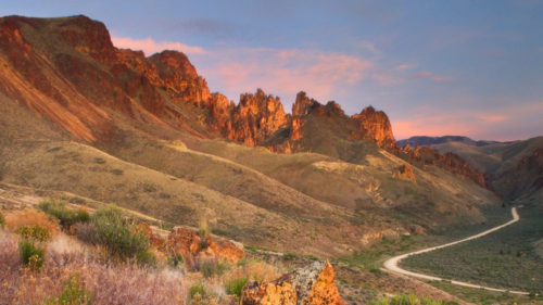
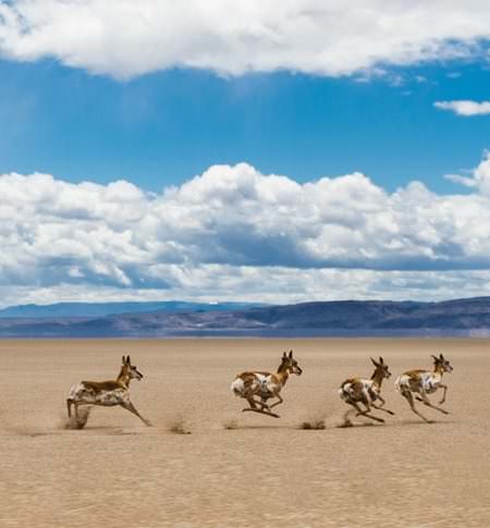
The 750-mile trail Fenty sketched out in 2010, with one terminus just east of Bend and another just short of the Idaho border, linked some of Eastern Oregon’s most spectacular natural areas: Steens Mountain, a nearly 10,000-foot snowcapped peak overlooking the Alvord Desert and a clutch of hot springs; Hart Mountain, a national refuge for pronghorn antelope; and the Owyhee Canyonlands, more than 2 million acres of rugged wilderness populated with cougars, falcons and one of the country’s largest herds of bighorn sheep. ONDA practices conservation in many of these areas, removing defunct fences that interfere with antelope migration, monitoring declining sage-grouse populations and replanting areas that cattle have overgrazed.
Between 2011 and 2013, hundreds of volunteers ventured into the Oregon desert and tested the feasibility of Fenty’s proposed trail, bringing back detailed information about the terrain: streams, puddles and cattle troughs that could quench a hiker’s thirst; fences they had to climb over or crawl under; sections where it was difficult to find steady footing.
In 2013 ONDA composed a formal proposal to make the ODT a nationally recognized trail and submitted it to the Bureau of Land Management, which oversees the majority of public land in Eastern Oregon, as well as to the U.S. Fish & Wildlife Service, Fort McDermitt Paiute-Shoshone tribal chairman Tildon Smart, Deschutes and Lake county commissioners, and Malheur and Harney county courts. Designation is still pending. The hope is that one day the ODT will join the ranks of the country’s more than 1,000 National Recreational Trails, or possibly even be designated a National Scenic Trail, which would put it in the more select company of the Appalachian Trail, the Pacific Crest Trail and the Continental Divide Trail.
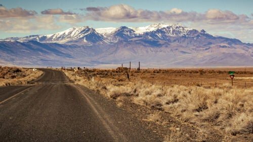
The ODT is not what most people picture when they think of a hiking trail. It is more conceptual than physical, more paper and pixel than groove and blaze. Although ONDA has carefully plotted the ODT on a series of detailed and freely freely available maps, there is no contiguous designated path through the desert. To navigate it from start to finish, you ideally need considerable experience with orienteering and cross-country hiking.
A Day in the Badlands
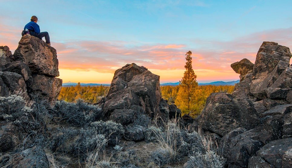
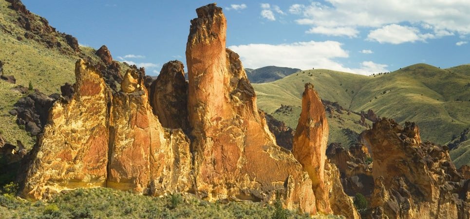
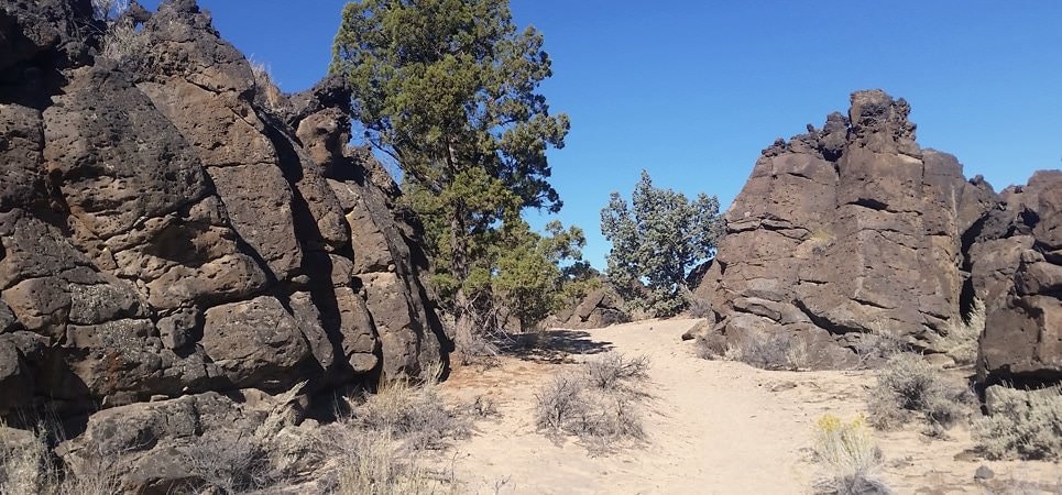
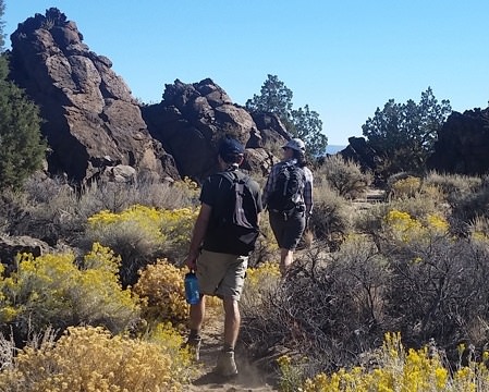
This past September, I traveled to the Badlands Wilderness to experience the ODT firsthand. At Flatiron Rock Trailhead, about 11 miles east of Bend, Gena Goodman-Campbell, ONDA’s Central Oregon coordinator, and I rendezvoused with Renee Patrick, the Oregon Desert Trail coordinator at ONDA. Patrick had already been on the trail for two weeks, hiking sections she had not scouted before. The three of us set off through the high desert: a vast expanse of powdery volcanic ash piled upon lava rock the color of a freshly dried scab — testaments to Oregon’s long history of geothermal transfiguration.
Oregon has endured some of the largest and fastest-flowing lava floods in Earth’s history. As recently as 74,000 years ago, molten basalt oozed out of the earth and smothered what is now the Badlands Wilderness. Once the initial flow spread about 8 to 10 inches thick, it began to slow and developed a crust. Continually gushing magma ballooned and wrinkled this outer shell, sometimes forming swells 5 to 60 feet high, which eventually cracked and cooled, creating the jagged ridges, slabs and caves we see today
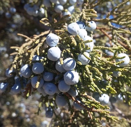
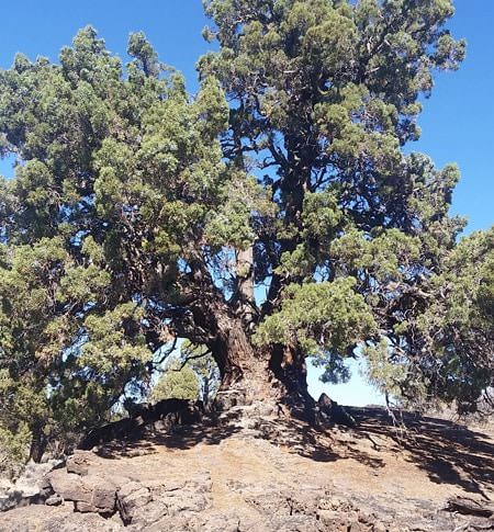
Sprouting from the volcanic substrate all around us were scores of striking juniper trees striped blonde and red, their long roots weaving in and out of the sand like sea serpents, their trunks swirled like narwhals’ tusks, their branches suspended in clouds of smoky blue berries. Beneath the trees grew thickets of rabbitbrush, sagebrush and wild purple daisies. A kind of gray vegetable fuzz coated many of the rocks: mats of dehydrated algae, fungi and moss known as “biocrusts.” When we gave them sips of water, they instantly unfurled tiny green wreaths, like secret anemones of the desert. Pinyon jays flitted from one tree to the next. Cottontail rabbits hid in the shade. Western fence lizards scuttled across logs. And now and then we encountered overlapping lines of pea-size footprints in the sand: highly trafficked rodent crosswalks.
In all we hiked about 9 miles in five hours, stopping a few times to rest or have lunch beneath a juniper tree, winding our way westward to another trailhead, where we had stowed a car for the short drive back into Bend. For most of that time, we followed a faint path worn into the desert by decades of car and foot traffic (after Congress designated the Badlands a wilderness area in 2009, cars and bikes were banned). At one point, however, we had to cross a tract of untrammeled desert from one trail to another. We could feel our feet breaking through a thin crust of desiccated sand into the pillowy depths beneath, which billowed around our shoes like clouds of talcum powder. In our wake we left a chain of large oval depressions, reminiscent of boot prints on the moon.
On her far more ambitious and exacting trip, Clegg found the ODT to be both a unique challenge and a joy. Before embarking, she spent a lot of time with dental floss and maps, measuring out how long she could travel without a water cache; on the trail, she relied on ONDA’s maps and a GPS device. “Nothing really compares,” she says. “I had to constantly pay attention and engage with the landscape around me just to make sure I didn’t get lost. But it gave me the ultimate freedom to be creative, to navigate the details however I wanted. I really enjoyed that.”
Patrick is continually improving ONDA’s online resources and plans to release a new series of guides tailored for day-hikers, as well as more detailed information for thru-hikers. In 2015 about 20 people explored the ODT; in 2016 that number jumped to 50, according to Fenty. So far 10 people have completed the trail in its entirety. “At this point, we don’t have plans to build an actual trail in the field,” Patrick says. “The feedback I’m getting is that it’s unique to have something more like a remote desert exploration experience, with the help of a guidebook.”
That is a sentiment Clegg shares. “I love that there’s a mapped-out public path through the wilderness, all the way from Bend to Idaho,” she says. “That’s fantastic. It gives you the gist of the route you can take in order to know this place in a new way. For me, that’s the important part: that people get out there and see what this land has to offer, the value of our public shared spaces and what it means to be such a small person in such a huge world.”