








Travel Oregon’s first priority is the safety of our residents and visitors. Review the latest travel alerts and warnings relevant to your Oregon trip and learn how your trip may be affected.

Travel Oregon’s first priority is the safety of our residents and visitors. Review the latest travel alerts and warnings relevant to your Oregon trip and learn how your trip may be affected.
Oregon is a big state. Wildfires can affect travel in parts of Oregon, but impacts are often localized. Check the current alerts below to see whether your destination is affected. If you’re looking for general guidance about traveling during wildfire season, read our Wildfire Travel FAQ. The AirNow Fire and Smoke Map is also a good tool to see if smoke is in your area. Also note:
Check the region’s frequently updated travel page for alerts before you visit, including some evacuation orders and trail closures in the Mt. Hood National Forest.
Northeast Oregon (Wallowa County)
Northeast Oregon (Union, Umatilla counties)
Northeast Oregon (Baker County)
John Day Wilderness (Grant County)
Crook & Jefferson counties
Southeast Oregon (Harney County)
Southeast Oregon (Malheur & Owyhee counties)
For more county-specific updates on evacuations, road closures and other local developments, check with the pages here: Gilliam Co, Wheeler Co, and Harney Co and Elkhorn Media Group. Check current Eastern Oregon road closures before you travel.
Ochoco National Forest (Crook County)
Warm Springs (Jefferson County)
North of Sisters (Jefferson & Deschutes counties)
Grants Pass & Rogue River (Jackson & Josephine counties)
Umpqua National Forest (Jackson & Douglas counties)
Fremont-Winema National Forest (Klamath County)
Stay posted for alerts and always check the wildfire dashboard before you set out.
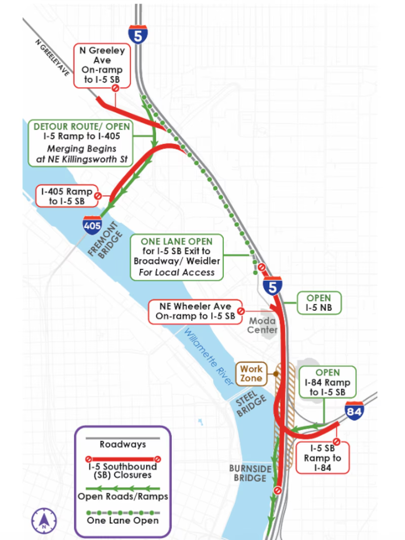
Travelers in and around Portland should be aware of the Southbound I-5 closure scheduled 24/7 for five weeks between Sep. 11-Oct. 16, 2026, just south of the Moda Center. The Oregon Department of Transportation will be performing repair work.
The closure will significantly impact travel times; it’s best to avoid morning or evening rush hours and take alternative routes.
Recommended detours:
Oregon’s Welcome Centers (Portland International Airport, Ashland, Brookings, Seaside, Ontario, Klamath Falls, Boardman and Oregon City) are valuable resources for travelers exploring the state. Our team of friendly and knowledgeable travel advisors can assist visitors with recommendations and itinerary-building, as well as complimentary printed visitor guides, brochures, state highway maps, and more. Kindly check the operating hours before your visit, as some centers may experience temporary closures during winter months or major holidays.
Additional visitor information is available by calling 1.800.547.7842 (Monday -Friday) or submitting your question to us via [email protected]
