Traveler alert: Several hikes along this route were impacted by wildfire in 2017. Some parking was also affected, meaning parking availability is extremely limited, especially on weekends and holidays. Do not park in no parking areas. Check ReadySetGorge.com for trail conditions and TripCheck.com for road updates before you go. You’ll also find additional resources on our Travel Alerts page.
About 14,000 years ago, cataclysmic floods scoured out the Columbia River Gorge. Early visionaries engineered an inspired drive along its towering walls. As America’s first scenic highway and a National Historic Landmark, this 70-mile/113-kilometer route is indeed the “King of Roads.”
One of North America’s grandest rivers, the Columbia is at its finest as it rolls through the Columbia River Gorge, framed by sheer walls of basalt, cloaked in firs and ferns and rare endemic plants, accented with waterfall after crashing waterfall.
The nation’s second National Scenic Area, the Columbia River Gorge is also the largest and most densely populated, offering the amenities of urban centers close to the wild beauty of the outdoors. And that beauty is matched only by the stories that can be told here: of tribal people fishing, trading and thriving along its banks; of Lewis and Clark’s Corps of Discovery epochal 1805-06 journey; of pioneers launching their worldly possessions down its rapids; of Samuel Hill championing the nation’s first scenic highway and enticing generations of visitors to this heady, handsome place. It’s fitting that the Columbia River Gorge is known as one of the 7 Wonders of Oregon.
Troutdale to Crown Point
The Sandy River marks the western boundary of the Columbia River Gorge National Scenic Area, where the Portland metro area ends and the byway begins. From Troutdale (exit 17 on Interstate 84), the road follows the Sandy upstream, then winds uphill through Corbett to your first cliff-top panorama of the Gorge at the Portland Women’s Forum State Scenic Viewpoint.
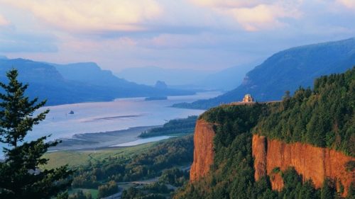
The majestic Columbia you see here begins as a trickle of snowmelt in the Canadian Rockies. It absorbs a tremendous web of river systems on its 1,200-mile/1,931-kilometer run to the Pacific, swelling into the nation’s fourth-largest river. This spot 725 feet above the river also provides a good look at the grand basalt cliffs of the Gorge, formed by Ice Age floods scouring through ancient lava flows between 18,000 and 13,000 years ago.
The vista-inspired railroad lawyer Samuel Hill and engineer extraordinaire Samuel Lancaster to “conquer” the wild beauty of the Gorge with a grand scenic drive. It was an implausible plan — a road that would cling to sheer cliffs, traverse rushing rivers and tunnel through hammer-hard basalt — but they made it happen. The first segment was dedicated in 1916, an engineering marvel and a craftsmen’s showcase of hand-cut stone and elegant masonry. The first destination built along the new road, the 1918 Vista House has displays about the highway construction and unmatched Gorge views from the rotunda atop Crown Point, 1 mile/1.6 kilometers past the first scenic overlook.
A World of Waterfalls
From Crown Point, the byway drifts down the mountain in gentle arcs suitable for touring cars from the early 20th century, showcasing the highway’s original stonework. You’re soon immersed in a deeply shaded, ferny oasis, where one waterfall after another tumbles from Gorge rim to roadside.
In 8 miles/12.8 kilometers, the byway skirts the base of five significant falls: Latourell, Shepperd’s Dell, Bridal Veil, Wahkeena and the granddaddy of them all, 620-foot Multnomah, one of the tallest waterfalls in the nation. Many have viewing areas and bridges close enough to feel the mist and thunder. Trails lead to more falls hidden deeper in the forest. East of Crown Point, family-friendly Latourell Falls is a 2.4-mile loop that travels past two plunging waterfalls.. Farther along the interstate, you can spot a segment of the historic highway restored as the Historic Columbia River Highway State Trail for bicycle and pedestrian use. Given their beauty and proximity to the highway, these waterfalls are popular hiking spots, especially on the weekends.
Bonneville Lock and Dam to Hood River
At exit 40, Bonneville Lock and Dam was the first of many dams to tame the Columbia. The extensive Visitors Center includes an underwater window where you can watch fish wriggling up the fish ladder to bypass the hydropower turbines. Visitors should stop in to the Sturgeon Viewing Center for the chance to spot Herman the Sturgeon — 10 feet long, 425 pounds and more than 60 years old.
Before the dams, the Columbia churned through nearby Cascade Locks in a 7-mile/11.2-kilometer series of falls and rapids known as “The Great Chute.” Today sternwheeler boat tours paddle through this particularly dramatic stretch of the Gorge, where the river cuts through the Cascade Range. The Pacific Crest National Scenic Trail descends from the mountains and crosses the Bridge of the Gods to Washington. Cascade Locks’ shady riverside setting, campgrounds, brewpubs and other services make it an appealing stop for hikers and cyclists.
Kiteboarders and windsurfers frequent the Hood River area, 18 miles/28.9 kilometers east, taking advantage of the natural wind tunnel formed by the Gorge. This appealing outdoorsy town is also the gateway to the Mt. Hood Scenic Byway. Carved out of the Gorge’s walls high above the river, the Twin Tunnels Trail is a sublime 5-mile/8-kilometer section of the Historic Columbia Highway State Trail for cyclists and pedestrians (closed to motorized traffic), and named for long tunnels chiseled through the basalt as part of the original road. Scenic overlooks abound.
Mosier to The Dalles
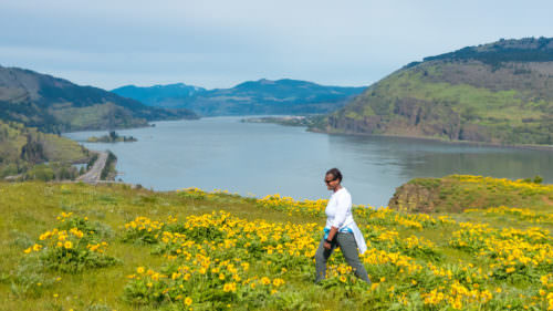
The byway rejoins the historic highway at exit 69 in Mosier, the east end of the Twin Tunnels Trail. Here the Gorge transitions from the fir forest of the Western Cascades to the semi-arid plateau of ponderosa pine and oak savanna to the east. A viewpoint atop Rowena Crest showcases dramatic geology, and footpaths lead into the Tom McCall Preserve, a bounty of spring wildflowers and several endemic plants found only in the Gorge. The byway makes a spectacular snaky descent down the Rowena Loops, a route featured in several car commercials.
The eastern gateway to the Gorge, The Dalles was long a Native American gathering place. Downtown murals document its rich 19th-century heritage, first as a Lewis and Clark encampment, then as a staging area for Oregon Trail pioneers readying for the treacherous trip down the Columbia’s rapids. The Columbia Gorge Discovery Center brings the region’s natural and cultural history to life. The stunning geologic beauty of the Columbia River Gorge combined with its incredible access to the outdoors and its friendly small towns will draw you back again and again.
Want more details?
Order a free Oregon Scenic Byways guide.