Two of Oregon’s nationally designated Wild and Scenic Rivers lead the way on this 172-mile/277-kilometer route, an ever-changing feast of white water, waterfalls and deep gorges gouged in the deeply forested southern Cascade Mountains.
When it comes to rivers, Oregon has an embarrassment of riches. The Rogue and the Umpqua are two of its most storied, both for their world-famous fishing and rafting and for their primal beauty. This route first travels up the North Umpqua River from I-5 at Roseburg, then arcs back down the Upper Rogue River to Gold Hill, just a short drive back to the interstate. With abundant opportunities for hiking, fishing and camping, the Rogue- Umpqua Scenic Byway explores one of the state’s best-loved areas.
Roseburg and Glide
Traditionally a timber town, Roseburg today is known for outstanding recreational fishing as well as a growing number of wineries and microbreweries. Get a below-the-water look at the action at the Winchester Dam fish ladder, just 5 miles/8 kilometers north of the city, where trout, salmon, steelhead and other fish funnel past a viewing window on the North Umpqua River. The acclaimed Douglas County Museum documents the region’s varied past, with exhibits that include fossils, Native American artifacts, logging equipment and one of the state’s most extensive collections of historic photographs.
The region’s mild Mediterranean climate is ideal for wine grapes. Tasting rooms at area wineries let visitors sample what has steadily grown into one of the Pacific Northwest’s most acclaimed wine-producing regions. Varied, hilly terrain creates microclimates that allow a wide range of varietals to thrive here, including tempranillo and sangiovese.
From Roseburg, the byway leads east through scenic oak-dotted hills and meets up with the North Umpqua near Glide. It’s an unusual encounter: At a spot known as Colliding Rivers, the North Umpqua and Little River merge head-on in a swirl of white water.
North Umpqua River
Traveling upstream, the byway closely follows the North Umpqua, well deserving its “Wild and Scenic” designation. You’ll likely spot anglers casting for trout, salmon and the Umpqua’s most prized game fish, summer steelhead, native oceangoing rainbow trout that can reach 20 pounds. Guide services and fishing cabins dot the woodlands here, along with getaways like the Steamboat Inn, which has hosted a who’s who of celebrities. Hikers and mountain bikers will be equally captivated by the North Umpqua Trail, winding for 79 miles/ 127 kilometers along the river’s banks, past crashing rapids and through old-growth forest. Thirteen trailheads provide access.
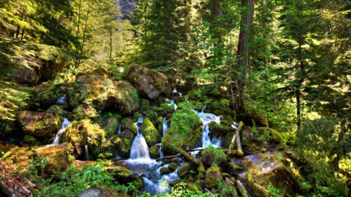
The rush of water and cool shade of the forest are constant companions as the byway winds through the Umpqua National Forest and Bureau of Land Management lands. With more than 15 cascades along its route, the byway has earned the nickname “Highway of Waterfalls.” Several overlooks offer views of the river’s canyons and roiling white water. Well-marked trails lead to cascades like Toketee Falls, a double-tiered waterfall, and to 272-foot Watson Falls, one of the highest in Southern Oregon. Just off the byway you’ll find Lemolo Lake Resort, a quiet hideaway known for its record-size brown trout.
Diamond Lake to the Rogue
Past Toketee Lake, OR-138 bids farewell to the North Umpqua and turns south to skirt the shores of Diamond Lake. Framed by 9,200-foot/2,804-meter Mt. Thielsen and 8,363-foot/2,549-meter Mt. Bailey, Diamond Lake is indeed a jewel of the Cascade Mountains. In summer and fall, visitors enjoy resort facilities, horseback riding, boating, swimming, hunting, fishing and cycling a paved path around the lake. Come winter, Diamond Lake Resort becomes a popular snowmobiling hub and also the base of operations for snowcat skiing and snowboarding on Mt. Bailey.
At the south end of Diamond Lake, OR-138 continues south toward Crater Lake National Park. To see Crater Lake, depart briefly from the byway and follow part of the Volcanic Legacy Scenic Byway. The Crater Rim Viewpoint looks east toward the peaks and ridges ringing Crater Lake. The Rogue-Umpqua Scenic Byway joins OR-230 and swings southwest into the Rogue River-Siskiyou National Forest, where the Rogue emerges from underground lava tubes.
The Upper Rogue River
The route descends past old-growth firs and lava flows and into the Rogue River canyon, joining the river as it heads downstream. The byway joins OR-62 just north of Union Creek, the western terminus of a wagon road for settlers crossing the Cascades. A short path leads to an observation platform overlooking the Rogue Gorge, a collapsed lava tube where the river now courses through a 25-foot-wide, 40-foot-deep chasm. A mile/1.6 kilometers south, the Natural Bridge interpretive site explains how the river disappears through an underground lava tube, forming a land bridge.
The byway passes several campgrounds and fishing spots as it follows the Wild and Scenic Rogue downstream. Like the North Umpqua, the Upper Rogue supports endangered populations of chinook and coho salmon, as well as cutthroat trout and steelhead. At Joseph H. Stewart State Recreation Area, the river widens into Lost Creek Lake, popular for boating and fishing. Just beyond the lake, the Cole Rivers Hatchery raises and releases salmon and steelhead into the Rogue and Applegate rivers each year. Farther south, Shady Cove is a popular departure point for anglers and rafters floating the Upper Rogue.
The byway joins OR-234, where several waysides entice travelers to linger along the river with a fly rod or a picnic lunch. The route ends at Gold Hill, less than an hour from the bustling Rogue Valley cities of Medford, Ashland and Grants Pass.
Want more details?
Order a free Oregon Scenic Byways guide.