


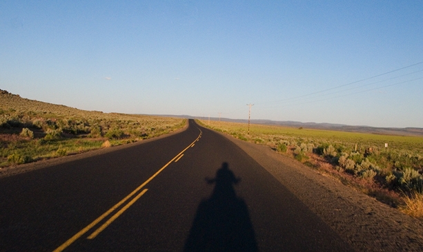
I’m 300 miles southeast of my home in Portland and I’m spending the next three days exploring Oregon’s most remote region.
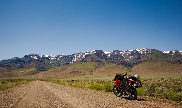
Armed with only a loose plan to head east into the Owyhee country and explore some back-road canyons on my motorcycle, I’ve left plenty of room in my itinerary for spontaneous turns down interesting-looking paths, frequent stops for photos and a goal to take the most lightly traveled roads I can find.
Day One
I start my journey in Seneca, a former logging town with 200 or so souls quietly nestled in Bear Valley, in the shadow of the Strawberry Mountains. Taking my coffee on the front porch, I feel a chill in the morning air that hints at Seneca’s reputation as the coldest place in Oregon. Fortunately, that record of negative 54 degrees set in 1933 won’t be a problem on this late summer morning.
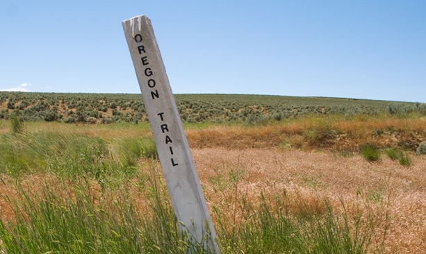
Following the Oregon Trail
My first leg of the day winds along the southern edge of the Strawberry Mountains, through thick ponderosa pine forests and lush meadows; it crosses the headwater of the Malheur River with stunning views of the jagged peaks to the north.
The crisp morning air is perfumed with lupine, and a large canine sprints across the road in front of me, either the biggest coyote I’ve ever seen or perhaps one of the wolves that are re-establishing themselves in these mountains. The road is paved but narrow, at times going down to a single lane, and it twists, climbs and drops its way through this rugged backcountry.
Over the next 60 miles I pass but one vehicle. Paradise.
Midday is much hotter, and I shed layers before heading south on secondary roads, making my way across Keeney Pass where wagon ruts along the original Oregon Trail are still visible.
As I ride along on my modern fuel-injected machine, loaded with GPS and digital cameras, I find it hard to even imagine what the pioneers endured to cross this rugged land.
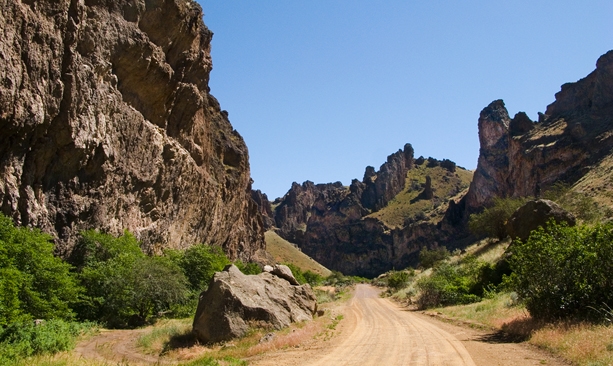
Journey through the Giants
Cresting a hilltop I have a “wow” moment as I see the road descend then disappear a few miles ahead into a stark crack in the earth.
Entering the steep-walled canyon, I stop every 100 yards or so to admire the stunning geology of the giants that are the sheer rock walls surrounding me.
Climbing out of Succor Creek Canyon the road gets steeper, commanding my full attention as I pick my way up to the pass toward Leslie Gulch. Here the road descends to a dry creek bed through spires and towers of volcanic tuff, eroded by wind and water over the millennia.

Oregon’s Basque Land
This was the land of the Northern Paiute, Shoshone and Bannock tribes, who lived here until European trappers and prospectors arrived in 1830s.
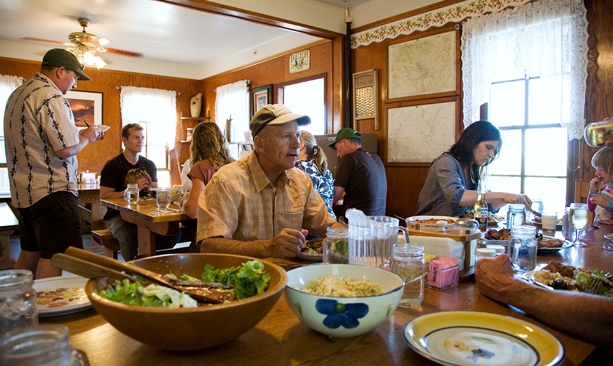
In the 1890s the Basque people came from their homeland in the Spanish Pyrenees Mountains and brought with them the skills of sheepherding and masonry. Jordan Valley remains steeped in Basque culture as evidenced by the city’s pelota (handball) court, restored by local craftsmen in 1997.
When I arrive, just as the sun is setting, I head over to The Old Basque Inn with food on my mind. The Inn, built in 1903, originally a boardinghouse for newly arrived families, has remodeled rooms with shared baths.
After happily stuffing myself, I make it upstairs only to collapse on the comfy bed.
Day Two
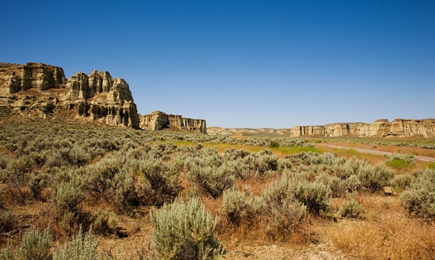
Jordan Valley is in the small section of Oregon on Mountain Time, so sunrise is even earlier, and by the time I finish breakfast it’s quite warm without a cloud in the sky. I start with a short detour off the main highway past the Pillars of Rome, stunning geological formations featuring 100-foot clay cliffs.
High Desert Wildlife
In the distance, snowcapped Steens Mountain beckons and I soon find myself turning onto Fields-Denio Road, which runs 60 miles along the eastern front of the massif with dramatic views of the Alvord Desert.
The Alvord never fails to surprise, and this day I see a huge flock of white pelicans circling above Mann Lake. The late and wetter-than-normal spring has left the desert grasses lush and green, with wildflowers everywhere.
A pronghorn antelope runs along the road in front of me, and as I look to my left I see about a dozen of his friends running alongside. I stop for a moment and kill the engine, taking a time-out to listen to the quiet, broken only by the wind across the desert grasses.
Parts of the Alvord Desert are not completely dry yet—and I don’t want to take my chances. Getting stuck out here by yourself would be a mistake; AAA won’t be coming to get you. But the western edge of the desert is baked white and plenty safe to explore before I head to Fields Station for lunch.
After filling my stomach and my gas tank I head onward toward the oasis of the Malheur Basin.
Here the variety of birds is remarkable. I watch a white-faced ibis gracefully glide over the grasses, listen to yellow-headed blackbirds singing and count scores more species I can’t name.
Homesteads and Hot Springs
It was this lush valley that caught Pete French’s attention when he arrived in 1872 after herding 1,200 head of cattle some 500 miles.
French settled and built an enormous cattle operation, before being murdered by an angry homesteader in 1897. The hamlet Frenchglen honors his legend, and stories of French’s ruthlessness abound here. It’s hard to separate truth from myth but it’s safe to say he left his mark on this fascinating corner of Oregon.
No more than a dozen or so folks call Frenchglen home, but the town does boast the Frenchglen Hotel. John Ross, the innkeeper and head chef for the past 20 years, serves delicious family-style dinners at this historic oasis. After dinner I push on to an even smaller town—Diamond, Oregon, population: six.
Arriving at dusk, I find the Hotel Diamond empty but discover the key to my room, a welcome note and an ice-cold IPA in the fridge, which I enjoy on the screened wraparound porch, watching the day’s last light fade away.
Day Three
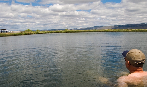
Back on pavement the next morning and headed north, I’ve got my sights set on a little personal indulgency: Crystal Crane Hot Springs, with its private soaking tubs and a pond with views of the desert landscape. I unwind while soaking my weary muscles in 100-degree waters.
Prehistoric Panorama
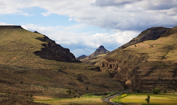
At lunch I plot my journey northward toward John Day, staying away from main roads and heading deep into the Malheur National Forest. My route soon disappears into the giant crack in the earth that is Picture Gorge, and I spend the next couple of hours knocking around the John Day Fossil Beds’ various units and overlooks.
Arriving in Mitchell as the sun sets, I find a comfortable room in the historic Oregon Hotel. A hearty dinner and a cold beer at the Little Pine Café next door put the cap on my day, and I soon fall into a deep slumber.
Waking early, I take my coffee on the front porch again and load my gear for the ride back home.
First I want to make a stop at the Painted Hills for some final explorations. There’s clarity to the light, as if the previous day’s rains had washed out all the impurities, and the multihued landscape glistens.
On this morning I have the 3,100-acre site to myself and I’m tempted to linger, taking in all that surrounds me. But then I see another dirt road and I realize I don’t know where it goes. So, of course, I have to take it.