This week, I embarked on a trek to discover Ki-a-Kuts Falls, a picturesque waterfall along the Tualatin River only accessible through a rugged hike through a forest of towering trees.
The Tualatin River meanders thru neighborhoods and industry on the western edge of the Greater Portland area. It is a slow moving stream flanked by towering trees that puts on quite a colorful show each fall.
Yet, natural drama is only part of the Tualatin River’s story on a getaway that takes effort, planning and persistence according to a small platoon of adventurers from the Tualatin Riverkeepers (TRK), a local conservation group. The group had gathered at Menefee Park in Yamhill County to compare notes and prepare their gear for a day long hike into one of the most stunning and surprising sites of the Tualatin River watershed.
“It’s rugged, it’s treacherous and you need a good topo map, a compass and a GPS would help you find it,” noted longtime Tualatin Riverkeeper Paul Whitney.
Tarri Christopher, a TRK member agreed, “Not everyone can do this. This isn’t ‘take your entire family and go on a stroll’ hike. You have to be prepared – you have to be fit.”
Fit enough to tackle steep, relentless and unforgiving terrain along the upper Tualatin River in the Oregon Coast Range Mountains.
Lew Scholl joined the expedition too. He had been on a trip like this before but way back in 1993 when he accompanied five friends from TRK who stumbled onto this remote stretch of the river.
It was meant to be a two-hour hike but it turned into an all day bushwhack.
“The six of us got together and we were led by then-TRK President Rob Baur. We really didn’t know what we were getting ourselves into as there was no trail and we constantly had to wade across the river, doing whatever it took to get downstream.”
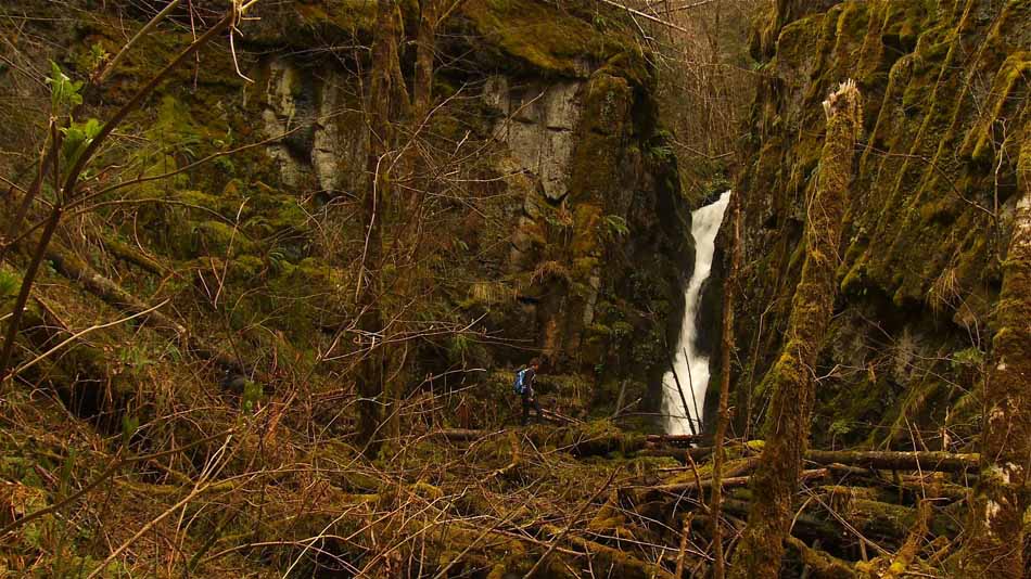
After hours of scrambling and rambling up and down the steep-walled river canyon, marked by big trees, hug boulders and sheer rock cliffs the group heard something loud and constant.
Scholl said it sounded like thunder, but it was a waterfall that wasn’t on any map.
“We looked at each other and said, ‘Hmm, that sounds like water rushing,’ and we got up on some rocks and looked down and holy smokes, it’s a 45 foot waterfall!”
The thick cord of whitewater rushed and then spilled out of a hidden cleft in the ancient basalt rock. It was certainly a well-deserved reward for his efforts, but Scholl couldn’t really believe that no one had ever heard of it.
“It was interesting because obviously the area was logged over. So, someone knew about the falls at one time. In a way, we re-discovered the falls.”
Scholl added that they submitted a name for the waterfall to the State Geographic Names Board and eventually the waterfall was added to government maps. In 1999, the Confederated Tribes of the Grand Ronde recognized through a tribal ceremony the cascading “Ki-a-Kuts Falls,” (kia-cuts) named for the last chief of the Atfalati Indians, a local band of Kalapuya Indians.
“The Elder KiaKuts stood up for his people back when Joel Palmer of the US Indian Bureau tried to get the natives to move off their land,” said Scholl. “The chief said, ‘No, we don’t want to go to a distant reservation – we want to stay right here. Why can’t you make a reservation here for us? The only thing I want is for the settlers to stop harassing my children.”
“It’s a fitting name because the falls were not discovered by the Tualatin Riverkeepers,” added Tarri Christopher. “The falls were here long before any of us knew about it. Native people knew the place long ago, so it should be rightfully recognized that way.”
Flanked by basalt columns and cliffs, Ki-a-Kuts Falls is a timeless and serene moment that is fitting reward for the effort that it takes to reach the restful site.
Brian Wegener, a TRK member, added, “It is hard to believe it’s the same Tualatin River that most of us know in the Portland area. It is so different up here from what it looks like down in the valley. If you’re adventurous and in good health and you can use a map and compass and find your way, it’s a beautiful place to be.”
Tarri Christopher agreed and added, “If you see where it comes from – to see the beauty of it – I think we’re more likely to take care of it. It’s a special place and it’s worth the effort to get here.”
Special Note:
The Tualatin Riverkeepers is a good place to start for specific directions to Ki-a-Kuts Falls. It deserves special note that planning and preparation are critical if you want to visit KiaKuts Falls. That means good hiking boots with proper arch and ankle support, pack plenty of water, food, rain gear and a first aid kit.
Remember that it is a remote area with unreliable cell phone service and private logging roads. It is advised that you check with the Forest Grove office of the Oregon Department of Forestry for information about road closures.
You may also want to visit soon because when fire season begins, access roads through private timberland close down.