A pleasing detour for I-5 travelers, this 55-mile/89-kilometer pastoral route loops through a verdant park filled with waterfalls and rolling farmlands with distant views of the Coast and Cascade mountain ranges.
Woodburn to Mt. Angel
Shoppers often associate Woodburn with top-name designer goods and outlet bargains along I-5. Travel a few miles east to discover a productive agricultural area, too. The home of its founder, Jesse Settlemier, still stands proudly on a downtown corner. Nearby, a host of family-run Mexican restaurants line 99E and Front Street as testament to this historically Hispanic burg, which has the largest percentage of Latinos of any Oregon town.
Swiss-German heritage is evident in Mt. Angel, with its Bavarian-style architecture and a glockenspiel that plays four times a day. The community hosts the Pacific Northwest’s largest Oktoberfest every September.
Silverton
The route travels along OR-214 south toward Silverton, and the surrounding farms showcase some key Oregon crops, including hop vines (used in beer making), hazelnut groves and marionberries, a blackberry cultivar named after this county, Marion. A quick detour west on Downs Road leads to the 1917 Gallon House Covered Bridge, supposedly named for its covert whiskey sales during Prohibition. Silverton’s vibrant downtown makes a good lunch stop before an afternoon at the Oregon Garden, with 80 acres of specialty botanical gardens, concerts and other events. Stop for a look at the adjacent Frank Lloyd Wright Gordon House, the only Frank Lloyd Wright-designed house in Oregon.
Silver Falls
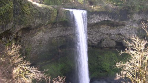
OR-214 twists and climbs past the Silverton Reservoir and through acre after acre of Christmas tree farms. Eventually they give way to a tall canopy of fir and hemlock as you approach Silver Falls State Park. More than 25 miles/40.2 kilometers of trail wind through this lush 9,000-acre park, Oregon’s largest. The Trail of Ten Falls passes above, below and even behind the park’s cascades, several more than 100 feet/30 meters high. Overlooks and short walks also provide worthy waterfall views.
The highway exits the south end of the park, descending out of forest and bending in broad S-curves through scenic farmland. Turn left on the Cascade Highway, passing through the rural hamlets of Sublimity, Aumsville and Turner to return to I-5.
Want more details?
Order a free Oregon Scenic Byways guide, or view a map of Silver Falls Tour Route online.