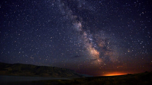
The delicate beauty of the high desert sweeps from horizon to horizon on this 171-mile/275-kilometer drive across the Great Basin, a landscape as vast as an inland sea.
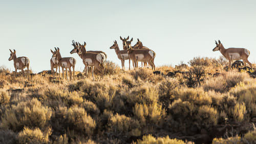
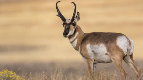
Welcome to the Oregon that many visitors don’t know exists — a place where the state’s archetypal lush forests and rushing rivers give way to sagebrush-dusted plains, alkali flats and rocky outcrops. An antidote to a busy world, it’s just the place to slow your pace. Gaze out at pronghorn (sometimes mistaken for antelope) grazing on golden grasslands, or the play of light on ancient rock. Such wide-open spaces and ample solitude may indeed be reminiscent of the Australian Outback. But as longtime ranchers and other ruggedly independent locals will tell you, this broad, beautiful landscape is 100 percent authentic Oregon.
La Pine to Fort Rock
The byway begins near La Pine (30 miles/48.2 kilometers south of Bend), first on US-97, then southeast on OR-31. Because the Cascade Range wrings nearly all the moisture from the clouds, the pine forests on the eastern slope of the mountains thin as you travel east, giving way to a high-desert landscape of juniper and sagebrush.
Fort Rock rises 325 feet out of the plain like a desert mirage. A national natural landmark, it takes its name from the fortress-like towering rock walls that form a near circle. It’s actually the ring of an ancient volcanic crater that was set in a shallow sea. Hikers can slip inside the walls, where wave action cut horizontal slabs into the rock. There’s evidence of human occupation dating back more than 10,000 years at Fort Rock and nearby Fort Rock Cave, where a University of Oregon archaeologist discovered sandals made from sagebrush bark. They’ve been carbon dated to be at least 9,300 years old, the oldest known shoes in the world. The cave is open to the public on guided tours through the state park only. (Reservations required; see the state parks website for dates.)
On the 7-mile/11.2-kilometer drive to Fort Rock, you’ll pass the Fort Rock Valley Historical Society Homestead Museum. It comprises several historic buildings from the valley, including a one-room schoolhouse, a church, a mercantile and settlers’ cabins, preserved and relocated by volunteers.
Silver and Summer Lakes
Just northeast of the small community of Silver Lake, Paulina Marsh attracts eagles, herons and waterfowl, especially in spring. Silver Lake, however, is a dry basin that fills with rainwater only once about every 30 years.
Soon the road crests to 4,830-foot/ 1,472-meter Picture Rock Pass, named for the Native American petroglyphs hammered into the rock just a short walk from the highway on the Medicine Man Trail. Atop the pass on a clear day, you can see the Three Sisters, a trio of Cascade Mountain volcanoes some 90 miles/ 144.8 kilometers to the northwest.
You’ll have a very different view descending the pass: Summer Lake, a long, shallow alkaline lake. With depths of 4 to 5 feet/1.2 to 1.5 meters, the lake contains no fish and sometimes dries up completely. The 18,000-acre Summer Lake Wildlife Area draws a wide range of waterfowl and is an important resting stop for birds migrating on the Pacific Flyway. Birders swoop into the area in early spring for the best viewing of sensitive, threatened or endangered species, including tundra swans and peregrine falcons. An 8.3-mile/13.3-kilometer auto tour route provides good viewing but is usually closed from October through mid-January for hunting season.
Paisley to Lakeview
At Paisley the byway makes the first of several crossings of the Chewaucan River, where anglers can cast for rainbow and native redband trout. Paisley is a good stop for services and perhaps a soak in the local hot springs. The nearby Paisley Caves, while not open to the public, are noteworthy for containing evidence of the oldest human presence in North America. Continuing southeast, you’ll catch a glimpse of some of the pasture lands of ZX Ranch — one of the largest cattle ranches in the nation.
At Valley Falls OR-31 joins US-395. To the east, the massive wall of Abert Rim rises up nearly 2,500 feet/762 meters and stretches 30 miles/48.2 kilometers, the largest exposed fault scarp in North America. It’s become such a popular launch for hang gliding and paragliding that nearby Lakeview dubs itself the “Hang Gliding Capital of the West.” Its ample array of launch sites, open landing areas and favorable wind conditions draw enthusiasts from around the world. Black Cap, a popular launch, provides grand views of the Goose Lake Valley.
Lakeview and Beyond
With an elevation of 4,800 feet/1,463 meters above sea level, Lakeview also claims the title of “Oregon’s Tallest Town.” It could come up with a geyser title, too: Old Perpetual, located within a hot springs resort complex 1 mile/1.6 kilometers north of town, is Oregon’s only geyser, shooting a column of water up to 50 feet/15 meters into the air. It has a history of erupting every 90 seconds but has become more temperamental in recent years; the geyser still goes off regularly from October to May.
For those interested in wildlife and even more remote, wide-open spaces, consider detouring 65 miles/104.6 kilometers northeast of Lakeview via Plush to the Hart Mountain National Antelope Refuge. Despite the erroneous name (you won’t find antelope here, but rather native pronghorn), the refuge played a vital role in reviving rapidly declining populations of pronghorn, the fastest land mammal in North America. The 275,000-acre reserve is also a haven for bighorn sheep, golden eagles and prairie falcons.
The Outback Scenic Byway ends about 15 miles/24.1 kilometers south of Lakeview at the state-line town of New Pine Creek. Goose Lake State Recreation Area, a full-service state park campground, offers a shady resting spot for those continuing south to California.
Want more details?
Order a free Oregon Scenic Byways guide.