The high points are many on this volcano-to-volcano, 140-mile/ 225-kilometer drive, where eons of eruptions and lava flows left a fiery heritage of cinder cones, pumice plains and unforgettable Crater Lake.
It’s so notable, Oregon put it on its U.S. quarter: Crater Lake anchors this drive through Southern Oregon, a national park of such beauty that it belongs on everyone’s bucket list. Along with looping around America’s deepest lake, this route also explores Oregon’s largest: Upper Klamath Lake, one of the West’s richest freshwater ecosystems. It attracts more than 1 million migrating birds — along with humans enjoying fishing, boating and other recreational opportunities.
Diamond Lake Junction to Crater Lake
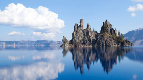
The byway begins on US-97 at Diamond Lake Junction, where OR-138 climbs west through the Fremont-Winema National Forest to Crater Lake National Park. (Because of snow, this entrance is often only open from about June through October. The southern entrance, accessible from OR-62, remains open all year.) The North Entrance Road leads into the park across a pumice desert moonscape, evidence of the massive eruption of ancient Mt. Mazama. Its crater collapsed from the force, forming the caldera that created the deepest lake in the United States — 1943 feet/592 meters.
Crater Lake’s depth is rivaled only by its brilliance, so pure it seems to glow an electric blue. Your first unforgettable look comes at Merriam Point near the North Junction, where the byway meets the Rim Drive, a 33-mile/53-kilometer road that encircles the lake. This rim route is popular with cyclists and, come winter, cross-country skiers.
Follow the Rim Drive clockwise so you can more easily pull off at the many overlooks. After skirting Steel Bay, the drive arrives at the Cleetwood Cove trailhead. It’s the only trail in the park that leads down to the water’s edge, and it is the departure point for ranger-led boat tours on the lake. Some tours stop at Wizard Island, which rises more than 700 feet/213 meters above the water’s surface.
Continuing clockwise, Skell Head and the short side trip to the Cloudcap Overlook provide excellent views of the entire lake. A hiking trail climbs up Mt. Scott, the highest point in the park. The Rim Drive dips away from the lake a few times en route to the south shore’s Rim Village. Stop here for a look at the 1915 log-and-stone Crater Lake Lodge and to check out the film and interpretive displays at the Steel Visitor Center. You can continue around Rim Drive here or get one last spectacular lake view from the Sinnott Memorial Overlook before exiting the park through the south gate.
Fort Klamath and Klamath Lake
From the national park’s south entrance, OR-62 leads southeast to Fort Klamath. Established as a U.S. military outpost in 1863, it now houses the Fort Klamath Museum, telling the story of the fort’s role in the Modoc War.
From Fort Klamath, the byway winds west and south, bending along the Upper Klamath National Wildlife Refuge and Upper Klamath Lake on West Side Road. Covering 133 square miles/214 square kilometers, Upper Klamath is Oregon’s largest freshwater lake; together with the adjacent wetlands and other area lakes, the Klamath Basin forms one of the largest freshwater ecosystems west of the Great Lakes.
A boat offers an ideal way to explore it. (Area concessionaires offer rentals.) Self-guided water trails, like the Upper Klamath Canoe Trail near Rocky Point, weave among marsh grasses and lilies. Anglers know Upper Klamath for its trophy-size native rainbow trout.
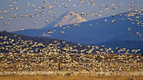
The waterways are a magnet for more than a million birds migrating up and down the Pacific Flyway. More than 300 different species pass through, including shorebirds like white-faced ibis, great egrets and sandhill cranes; raptors like American kestrels and northern harriers; and tens of thousands of geese, ducks and swans. It attracts the largest concentration of bald eagles in the Lower 48.
In the shadow of 9,495-foot/2,894- meter Mt. McLoughlin, the byway joins OR-140 and sidles up alongside the lake at Howard Bay. This is a good area to spot nesting white pelicans and bald eagles, which soar through the skies here year-round.
Klamath Falls
The byway passes through ponderosa pine, horse farms and cattle ranches before descending toward Klamath Falls at the lake’s southern end. Walking trails along the waterways just below the lake — the Link River and Lake Ewauna — are good spots to stretch your legs and do a little bird-watching.
Klamath Falls has been an important hub ever since the railroad arrived in 1909, bringing with it well-heeled travelers from San Francisco and Portland. A booming “entertainment industry” for loggers and ranch hands quickly sprang to life, too, with brothels, saloons and entertainment venues. A few architectural tributes remain, such as the 1905 Baldwin Hotel and the 1939 art deco Ross Ragland Theater. Also downtown, the Favell Museum displays more than 100,000 Native American artifacts, the works of more than 300 contemporary Western artists and a one-of-a-kind collection of miniature working firearms.
The byway continues on US-97 south of Klamath Falls, traveling through two more of the refuges in the Klamath Basin: Bear Valley National Wildlife Refuge and Lower Klamath National Wildlife Refuge. At the Oregon-California border, the Francis S. Landrum Historic Wayside commemorates the Applegate Trail, an alternative to the Oregon Trail used by pioneers headed for the Rogue River and southern Willamette valleys. Further south, the byway passes Tulelake, Lava Beds National Monument and Mt. Shasta, and continues on to Lassen Volcanic National Park.
Want more details?
Order a free Oregon Scenic Byways guide.