
Maybe Tualatin took inspiration from the Oregon Trail, the epochal pioneer route that ended just 10 miles east of here in Oregon City. A web of trails stitches through this town 20 minutes southwest of Portland, linking downtown businesses and leading off into parks and natural areas. You might also want to beat a path to Tualatin’s renowned retail areas, where great shopping always comes with that ever-popular Oregon discount: no sales tax!
Contemporary Town Center: A 3-acre lake and a fountain plaza anchor Tualatin Commons, a promenade of shops and restaurants. Conveniently located between the main access routes of Southwest Boones Ferry Road and Southwest Tualatin-Sherwood Road, it’s an easy place to park the car and access many of Tualatin’s trails. The 0.33-mile Commons Loop, 1.4-mile Wetland Loop and 0.5-mile Library Loop are part of the Tualatin Art Walk, featuring sculptures, murals, mosaics and other works.
Bones About It: In the 1960s, Tualatin resident and Portland State University geology student John George unearthed 14,000-year-old mastodon bones near present-day Tualatin Commons. Check out the reassembled skeleton at the Tualatin Public Library, and see more artifacts and displays about the Ice Age floods that shaped the Tualatin Valley at the nearby Tualatin Heritage Center.
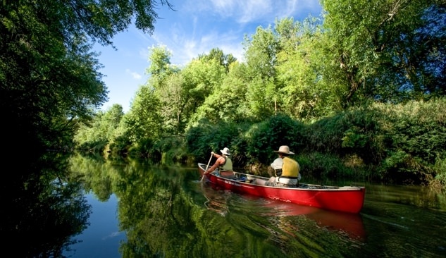
River Route: The Tualatin River bends gently through the city on its route from the Coast Range to the Willamette River. The Tualatin River Greenway Trail follows the river’s south bank and links several of the city’s riverfront parks. Enjoy the view from the Ki-A-Kuts pedestrian/bicycle bridge that spans the waterway at Tualatin Community Park. The park is one of several access points for the 40-mile Tualatin River Water Trail. In summer months, the current is usually mellow enough for an easy upstream paddle and a relaxing float. Rent canoes and kayaks from Tualatin Riverkeepers at Cook Park or Alder Creek Kayak & Canoe at Browns Ferry Park.
For the Birds: Local residents lobbied the U.S. government for the nearby Tualatin River National Wildlife Refuge, established in 1992 and one of just a few federal refuges in an urban area. Today this protected floodplain provides a haven for more than 200 species of birds and other critters. An interpretive center, an observation deck and a mile-long nature trail welcome visitors; from May through September, you can also walk through the refuge on 3 miles of gravel service roads. For another perspective on the Tualatin River watershed, stop at Ancestry Brewing. The taproom includes an outdoor deck with an expansive wetlands view.
Scenic Bikeways and Byways: Head west to discover the fertile Tualatin Valley. The 57-mile Vineyard and Valley Scenic Tour Route leads through a rich agricultural region of tidy farm fields, orchards, hazelnut groves and vineyards. Tasting rooms attest to the region’s preeminence as one of the nation’s top wine regions. The Tualatin Valley Scenic Bikeway winds through the valley on lightly traveled roads and connects with the car-free Banks-Vernonia State Trail.
Extend Your Stay: Spend the night right in the heart of Tualatin Commons at the Century Hotel or steps from upscale Bridgeport Village shopping at the Grand Hotel at Bridgeport.